Tenerife mapping party
A SDI (Spatial Data Infrastructures) conference is being hold in Tenerife from Nov 4th to Nov 7th. Why not to spend one more day in the island and help complete the map?
When : Saturday 8th November 2008 - Meet up at 11:00
Where : Catalonia Oro Negro hotel lobby, over here
Getting there
The best way to get there is flying to the Tenerife Sur / Reina Sofía international airport (IATA: TFS). You can also fly to the Tenerife Norte airport (IATA: TFN), which is 60 Km farther away, and hop in a bus.
From there, take a taxi to the Playa de las Américas suburb. This is a touristic area, so expect lots of hotels and restaurants nearby.
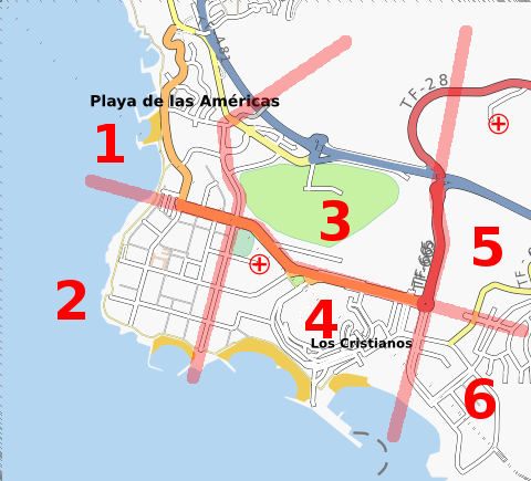
Cake diagram
If you're coming and willing to map, please choose a slice of the area to be mapped.
1. Ivansanchez
2.
3.
4.
5.
6.
Who's coming?
- Ivansanchez
- René Martín [Agarfu]
- Gubaer - currently cycling in Tenerife. Already mapped El Médano, San Isidro and footpaths to the Montaña Roja. Now cycling up to the Cañada. Today spent some time mapping and surveying Granadilla.
Contact
Ivansanchez at the talk@osm, party@osm, or talk-es@osm mailing lists.
René Martín at talk-es@osm mailing list or agarfu at gmail.
Leave a message on Gubaers discussion page.
