User:Lambertus
Bought a Garmin GPSmap 60CSx in March 2007 primary for recording and backtracking mountainbike routes. Being Dutch and therefore loving free stuff I decided to contribute to this project; mainly mapping Apeldoorn, it's beautiful surroundings (Veluwe) and pretty much anywhere else I go....
Contact: osm [at] na1400 [dot] info
Some photos taken while tracking
Contributions
The focus of my contributions for OSM is on:
- Cycle paths/routes and forest tracks on the Veluwe.
- Roads and cycle paths/routes in the municipally Apeldoorn.
- Managing the OSM forum.
- Creating Garmin maps and provide a distribution service.
- Bringing several opensource applications and OSM together to form a webbased routeplanner/navigation application, called YOURS.
Mapping
Since the addition of the AND data focus shifted to correcting the old data (as it seems to be last updated somewhere in 2002) and adding missing ways, cycleways, footpaths and tracks.
Frisian language map (Fryske kaart)
Early 2008 I started an initiative to make a map in the Frisian language. Fryslân is a Dutch province with a rich culture quite different from other parts of the Netherlands. It has it's own language (second official language) and has different place names among other things which justifies a separate mapping effort. The Frisian map is hosted on the Dutch tileserver, kindly sponsored by Oxilion. The Frisian map inspired other members of the Dutch OSM community to create a Carnival map where placenames are replaced with Carnival names.
OSM forum
In april 2007 I took over the unofficial forum from Dave Leverton (who actually set it up as a test) and began running it over at osm.na1400.info until it moved to the http://forum.openstreetmap.org domain (end of October 2007).
- The forum now uses the main OpenStreetMap userbase for authentication. No need for a separate forum username/password anymore.
Garmin maps
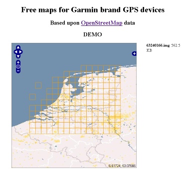
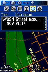
Since the AND data was imported, The Netherlands have the most complete road system in OpenStreetMap than any other country. This opens up possibilities for real use of the OSM data, so I decided to put Garmin maps together. They can be downloaded from: http://garmin.openstreetmap.nl . There is now also worldwide coverage for routable Garmin maps.

|

|
| Garmin map download website | GPSmap 60CSx selecting OSM map |
These maps have proven to be a good testing ground for the Mkgmap software which resulted in a lot of other people to produce Garmin maps for every part of the world.
Webbased routeplanner - YOURS
Now there is a reasonably complete coverage of data in the Netherlands the next step is to put the data to good use. A webbased routeplanner is a good example. I started working on a routeplanner for The Netherlands late May 2008 combining Gosmore routing engine, NameFinder service and OpenLayers. Pretty soon users requested support for their country as well resulting in a worldwide routing service named YOURS. It's pretty much a work in progress. More info on the forum and on the YOURS wiki page.
JOSM Terracer plugin
Wile mapping a lot of housenumbers I found that the Terracer plugin for JOSM could use some work, so I have enhanced and expanded the functionality of it:
- Keybind ESC to close the window (same behaviour as 'Cancel').
- Keybind Enter to close the window (same behaviour as 'Ok').
- Put focus on the first field ('lowest number') when the window opens.
- Allow non-numeric addresses (like 12a or 34-2) if only one number is entered.
- Don't process the building outline as if it were a housing block if only one number is entered as many free-standing buildings have non-symmetrical shapes (and there is nothing to terrace anyway).
- The interpolation option is now saved between plugin starts.
It took a lot of time to get accustomed with the Java quirks (no passing of variables by reference to functions for example) and getting a feel for the inner workings of JOSM, but the result is much better and it's really easy to map housenumbers on buildings now, even if it's a house that doesn't need terracing at all :-)
Interesting wiki pages
Personally used tags
I use the following tags which are not approved or proposed:
- wastewater = plant (node, polygon) where wastewater is treated
- wastewater = pumping_station (node, polygon) where wastewater is only pumped
- wastewater = basin (polygon) where wastewater is stored and/or treated.
- shop = garden_center (node, polygon) a shop where garden stuff is sold (plants, tools, etc.)
- historic = burrial_hill (node) an ancient man made hill where people used to be buried.
- man_made = watermill (node) machine/building that uses waterpower. Mostly historic sites.
- amenity = boat_rental (node) place where one can rent a boat.
- leisure = farmersgolf_course (polygon) area where one can play farmers golf (implies sport=farmersgolf).
Other OSM interests
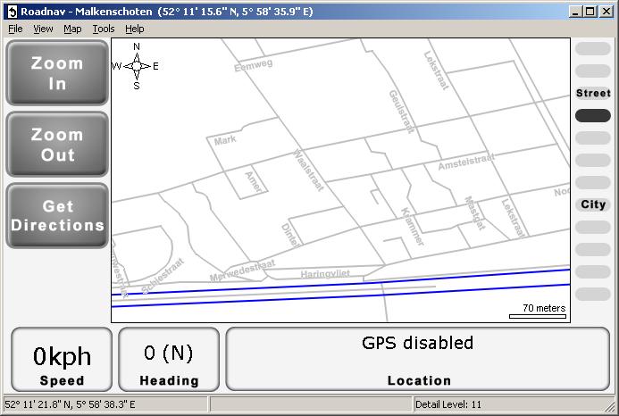
I like the idea of free data being used for navigation purposes. Especially as there are no proper cycle routeplanners. There are a few opensource software navigation applications around, one of which is RoadNav.
Below is an screenshot of RoadNav showing a part of Apeldoorn based on OpenStreetMap data. Cool eh?!

Quick preview
RoadNav does not seem to differentiate between footways, cycleways or any other kind of way (it renders them all the same), only important roads like primary, trunk and motorway are rendered differently. I'm curious how navigating a car over a footbridge is going to be like :-)
Things to do
- Downloading OSM data using the OSM webserver (through the API) seems to result in only partial data retrieval. So the best results were made using the file import function, though it is less user friendly.
- Importing the 800kb osm file required almost 900MB RAM, so the code needs to be tweaked before entire countries can be imported properly.
- Reviewing the RoadNav code shows heavy use of the double data type for storing the coordinates and calculations. This will be a show stopper for RoadNav if it has ambitions to run on embedded devices like PDA's. These devices mostly use ARM (like) processors which are almost always FPU-less. Rewriting the code to use 32bit integers for handling coordinates will be a priority. Converting to integers will probably be beneficial to the performance of the desktop/server version as well and should reduce the amount of memory required for storing the coordinates by half.
- Allow different views on the data to allow car- or cycle centric navigation.
Vandalism
Probably not intentionally graffiti, but all by the same user:
- http://www.openstreetmap.org/browse/way/32379748
- http://www.openstreetmap.org/browse/way/32284230
- http://www.openstreetmap.org/browse/way/32367351
MegaStar
 Lambertus is awarded a MegaStar for uploading one million track points.