Key:tunnel: Difference between revisions
No edit summary |
|||
| Line 2: | Line 2: | ||
== How to Map == |
== How to Map == |
||
[[Image:Mapping-Features-Tunnel-Road-Connection.png|right]] |
|||
When mapping a tunnel two things have to be considered: |
When mapping a tunnel two things have to be considered: |
||
| Line 7: | Line 9: | ||
The first is the layering of the different features. Which road is in the tunnel, and what features are above it? In the easiest case the tunnel gets the tag <tt>layer=-1</tt> while everything above doesn't have a layer tag (which means <tt>layer=0</tt>). Layers from -5 to +5 can be used. See [[Key:layer]] for details. |
The first is the layering of the different features. Which road is in the tunnel, and what features are above it? In the easiest case the tunnel gets the tag <tt>layer=-1</tt> while everything above doesn't have a layer tag (which means <tt>layer=0</tt>). Layers from -5 to +5 can be used. See [[Key:layer]] for details. |
||
Also that part of the road, railway, etc. which is in the actual tunnel (compared to ramps etc.) gets the tag <tt>tunnel=yes</tt>. A way leading through a tunnel has to be split up in order to be able to assign the tunnel tag to the part that is in the tunnel. |
Also that part of the road, railway, etc. which is in the actual tunnel (compared to ramps etc.) gets the tag <tt>tunnel=yes</tt>. A way leading through a tunnel has to be split up in order to be able to assign the tunnel tag to the part that is in the tunnel. |
||
If the tunnel ends in a junction you'll need a small un-tunneled way between the end of the tunnel and the junction (see image). |
|||
== Rendering == |
== Rendering == |
||
Revision as of 17:59, 10 February 2007
A tunnel is an underground passage for a road or similar.
How to Map
When mapping a tunnel two things have to be considered:
The first is the layering of the different features. Which road is in the tunnel, and what features are above it? In the easiest case the tunnel gets the tag layer=-1 while everything above doesn't have a layer tag (which means layer=0). Layers from -5 to +5 can be used. See Key:layer for details.
Also that part of the road, railway, etc. which is in the actual tunnel (compared to ramps etc.) gets the tag tunnel=yes. A way leading through a tunnel has to be split up in order to be able to assign the tunnel tag to the part that is in the tunnel.
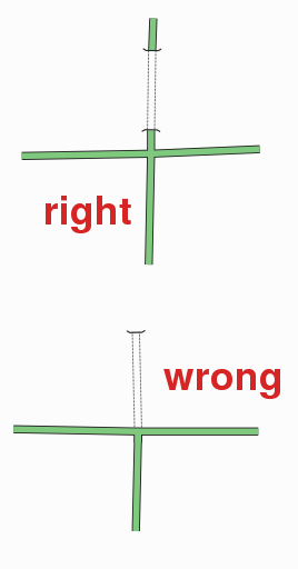
If the tunnel ends in a junction you'll need a small un-tunneled way between the end of the tunnel and the junction (see image).
Rendering
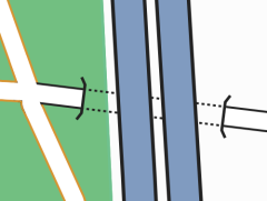
Osmarender (version 4) renders tunnels as dotted outlines with lines for the abutting face.
Mapnik currently ignores layers and tunnel tags.
Tags
| Type | Key | Value | Description |
|---|---|---|---|
| way | tunnel | "yes" or "true" | The tunnel itself |
| way | layer | -5 to 5 | Layering |
| way | name | Name of tunnel or road through the tunnel |
Open Issues
(Please use the Talk page if you want to discuss open issues.)
See also
For bridges see Mapping/Features/Bridge.

