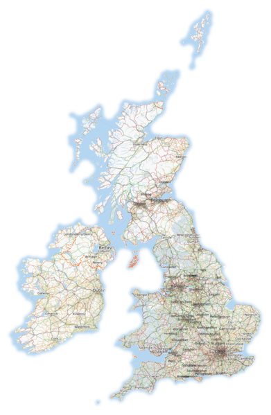
File:British isles osmarender August 2010.png
Jump to navigation
Jump to search


Size of this preview: 391 × 599 pixels. Other resolutions: 156 × 240 pixels | 313 × 480 pixels | 501 × 768 pixels | 1,227 × 1,881 pixels.
Original file (1,227 × 1,881 pixels, file size: 1.86 MB, MIME type: image/png)
not including rona/skule/st kilda, since they would only be a few pixels wide at this scale. channel islands have been cropped.
This is a Featured image, which means that it has been identified as one of the best examples of OpenStreetMap mapping, or that it provides a useful illustration of the OpenStreetMap project. If you know another image of similar quality, you can nominate it on Featured image proposals.
Front-page image for week 33 of 2010 (16–22 Aug.).
- Image descriptions
- Deutsch : 6 Jahre nach dem Start von OSM sehen die Britischen Inseln endlich einigermaßen gemappt aus.
- English : 6 years after OSM was started, the British Isles are finally starting to look mapped
- français : 6 ans après le démarrage d'OSM, les Îles Britanniques commencent enfin à avoir l'air cartographiées.
- italiano : 6 anni dopo l'inizio del progetto OSM, le Isole Britanniche iniziano finalmente a sembrare mappate
- lietuvių : Po 6 metų nuo OSM pradžios, britų salos pagaliau atrodo tinkamai pažymėtos
- polski : 6 lat od rozpoczęcia projektu OSM, mapa Wysp Brytyjskich zaczyna w końcu wyglądać na kompletną :)
- português : 6 anos após o OSM ser lançado, as Ilhas Britânicas estão começando a parecer mapeadas.
- suomi : 6 vuotta OSM-projektin alun jälkeen Britteinsaarten kartta alkaa näyttää kattavalta.
- русский : Спустя 6 лет после старта проекта OSM Британские острова начинают казаться прорисованными
- 中文(简体) : OSM 开始运作 6 年后,不列颠群岛终于看起来像张地图了。
- 中文(繁體) : OSM開始運作6年後,不列顛群島終於看起來像張地圖了。
![]()
Contains map data © OpenStreetMap contributors, made available under the terms of the Creative Commons Attribution-ShareAlike 2.0 (CC-BY-SA-2.0).
File history
Click on a date/time to view the file as it appeared at that time.
| Date/Time | Thumbnail | Dimensions | User | Comment | |
|---|---|---|---|---|---|
| current | 17:08, 14 August 2010 | | 1,227 × 1,881 (1.86 MB) | Ojw (talk | contribs) |
You cannot overwrite this file.