File:BrixtonPinMap.JPG
Jump to navigation
Jump to search


Size of this preview: 800 × 600 pixels. Other resolutions: 320 × 240 pixels | 640 × 480 pixels | 1,024 × 768 pixels | 1,280 × 960 pixels | 2,203 × 1,652 pixels.
Original file (2,203 × 1,652 pixels, file size: 988 KB, MIME type: image/jpeg)
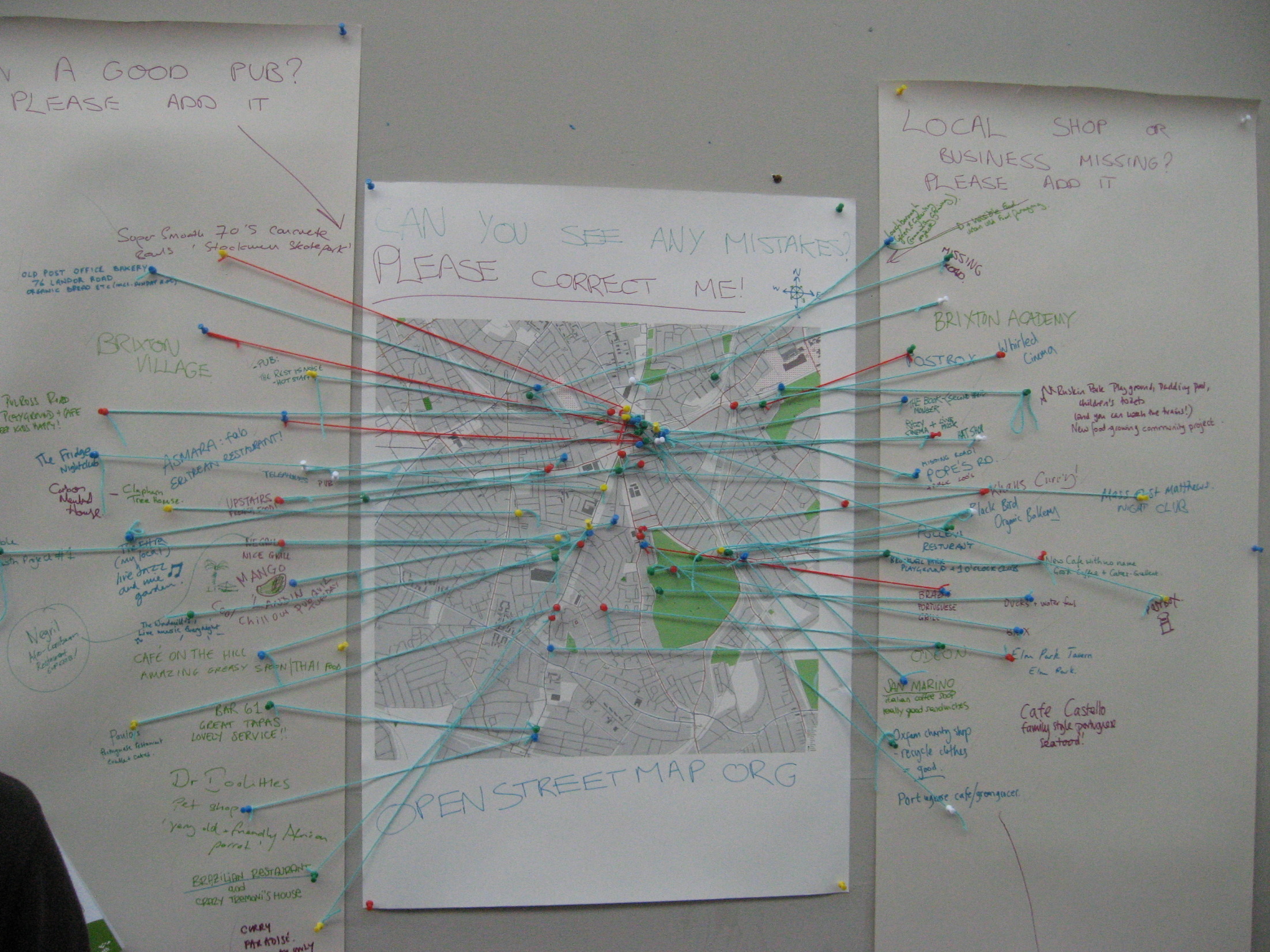
Picture of a map of Brixton that has had pins added by passers-by and locals indicating local POIs.
This was at the Spacemakers Brixton mini mapping party run by Ciaran Mooney
This is a Featured image, which means that it has been identified as one of the best examples of OpenStreetMap mapping, or that it provides a useful illustration of the OpenStreetMap project. If you know another image of similar quality, you can nominate it on Featured image proposals.
Front-page image for week 23 of 2010 (7–13 Jun.).
- Image descriptions
- Deutsch : Anwohner und Ortskundige ermutigen lokale POIs beizutragen. Pins auf einer Karte der Spacemakers Brixton mini mapping party
- English : Encouraging locals to contribute local POI information. Pins on a map at Spacemakers Brixton mini mapping party
- français : Encourager les habitants locaux à contribuer aux POI. Punaises sur une carte lors de la Spacemakers Brixton mini mapping party.
- italiano : Incoraggiamento degli abitanti locali a fornire informazioni sui punti di interesse (POI) del luogo. Puntine su una mappa allo Spacemakers Brixton mini mapping party
- lietuvių : Vietiniai gyventojai pažymi POI taškus per mapping vakarėlį Spacemakers Brixton
- magyar : A helyiek ösztönzése, hogy hozzájáruljanak helyi POI információkkal. Tűk a térképen a Spacemakers Brixton mini mapping partyn
- polski : Zachęcanie mieszkańców do uzupełnienia listy POI za pomocą pinezek na mapie podczas mini mapping party Spacemakers w Brixton
- português : Incentivando pessoas da localidade a contribuir com informações sobre Pontos de Interesse. Alfinetes em um mapa na mini-festa de mapeamento da Agência Spacemakers, de Brixton
- русский : Местные жители помогают добавлять точки POI, отмечая их булавками на карте в процессе минипокартушки Spacemakers Brixton
![]()
![]()
![]()
This work is licensed under the Creative Commons Attribution-ShareAlike 2.0 License.
Attribution: Ciarán Mooney
Attribution: Ciarán Mooney
license confirmation: https://www.flickr.com/photos/20156581@N03/4551378796/in/photolist-7Wc1md-7W8Lvc-7Wc37b-7Wc2aS-7Wc3Qb-7W8KwP-7WbZX7 also, on commons as https://commons.wikimedia.org/wiki/File:Full_view_of_Final_Map_(4551378796).jpg
.jpg)
File history
Click on a date/time to view the file as it appeared at that time.
| Date/Time | Thumbnail | Dimensions | User | Comment | |
|---|---|---|---|---|---|
| current | 19:23, 25 April 2010 | | 2,203 × 1,652 (988 KB) | Ciaran.mooney (talk | contribs) | Picture of a map of Brixton that has had pins added by passers-by and locals indicating local POIs. |
You cannot overwrite this file.
File usage
The following 9 pages use this file: