File:CirioDeNazare.png
Original file (1,311 × 768 pixels, file size: 793 KB, MIME type: image/png)
Summary
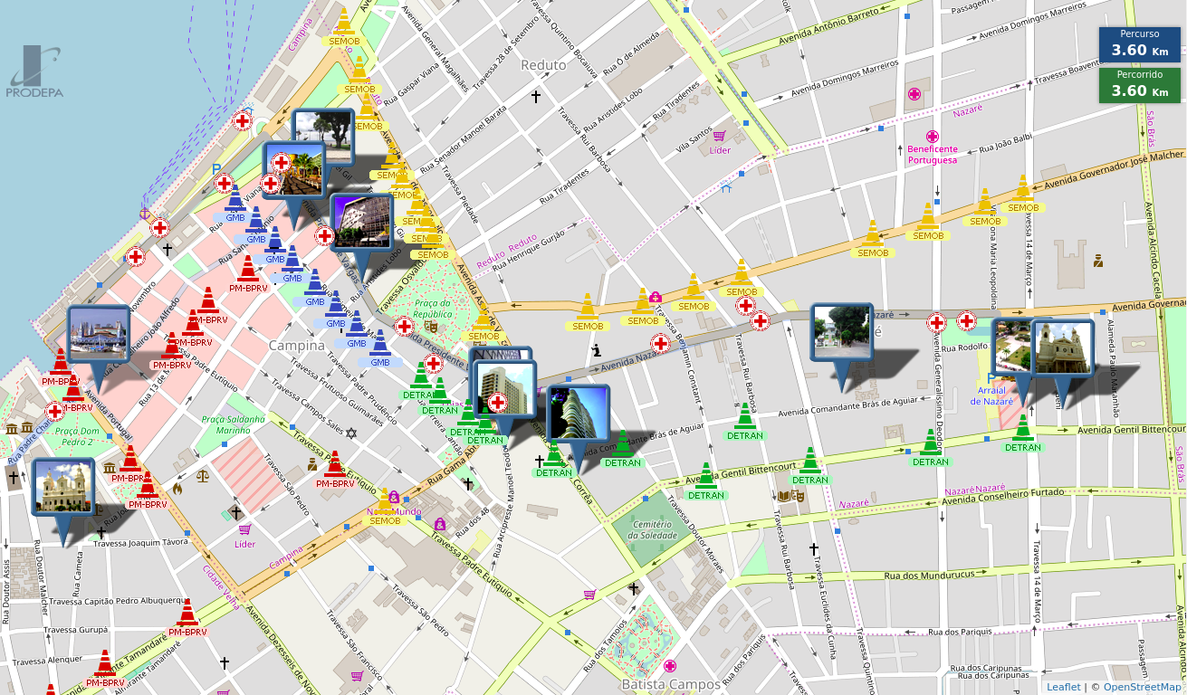
The “Círio de Nazaré” is a religious festivity that occurs in many places of the world. In Belém, State of Pará, Brazil, it gathers more than 2 million of people on a dozen processions that occurs during 2 weeks of October. The PRODEPA state agency created a web map that shows in real time the location of each procession and the streets blocks, as well as points of interest and temporary medical facilities.
Licensing
![]()
![]()
![]()
Attribution not specified as a parameter! THIS LICENSE ALWAYS REQUIRES ATTRIBUTION! Use {{CC-BY-SA-3.0|Attribution, typically name of author}} See Template:CC-BY-SA-3.0 for full description how this template should be used.
| Contains map data © OpenStreetMap contributors, made available under the terms of the Open Database License (ODbL).
The ODbL does not require any particular license for maps produced from ODbL data, produced maps may be subject also to other licences. |

Front-page image for week 42 of 2017 (16–22 Oct.).
- Image descriptions
- English : The PRODEPA state agency created an online map of the city of Belém, State of Pará, Brazil, showing the location of a dozen of processions, and of points of interest, temporary medical facilities and blocked streets, for the “Círio de Nazaré” religious festival, gathering more than 2 million people during 2 weeks in October 2017.
- français : L’agence d’État PRODEPA a créé une carte en ligne de la ville de Belém (État de Pará, Brésil) qui montre l’emplacement d’une douzaine de processions, ainsi que les points d’intérêt, les postes médicaux temporaires et les rues bloquées, pour le festival religieux « Círio de Nazaré » où se rassemblent plus de 2 millions de personnes durant deux semaines d’octobre 2017.
- italiano : L'agenzia statale PRODEPA ha creato una mappa online della città di Belém, Stato di Pará, Brasile, che mostra la posizione di decine di processioni e punti di interesse, postazioni mediche temporanee e strade chiuse, per il festival religioso “Círio de Nazaré”, che ha richiamato più di 2 milioni di persone nell'arco di 2 settimane a ottobre 2017.
- 中文(简体) : PRODEPA 州政府机构为巴西帕拉州贝伦市创建线上地图,显示“Círio de Nazaré”宗教盛会游行路线、兴趣点,临时医疗机构和封锁的街道。这次活动 2017 年 10 月两周活动期间,吸引超过两百万的民众参与。
- 中文(繁體) : PRODEPA 州政府機構為巴西帕拉州貝倫市創建線上地圖,顯示“Círio de Nazaré”宗教盛會遊行路線、興趣點,臨時醫療機構和封鎖的街道。這次活動 2017 年 10 月兩週活動期間,吸引超過兩百萬的民眾參與。
File history
Click on a date/time to view the file as it appeared at that time.
| Date/Time | Thumbnail | Dimensions | User | Comment | |
|---|---|---|---|---|---|
| current | 23:22, 8 October 2017 | | 1,311 × 768 (793 KB) | Wille (talk | contribs) | The Círio de Nazaré is a religious festivity that occurs in many places of the world. In Belém do Pará, Brazil, it gathers more than 2 million of people on a dozen processions that occurs during 2 weeks of October. A governmental agency created a [... |
You cannot overwrite this file.
File usage
The following 13 pages use this file:
- Featured images/Oct-Dec 2017
- List of featured images/2017
- Pt:Featured images/Oct-Dec 2017
- Uk:Featured images/Oct-Dec 2017
- Zh-hans:Featured images/Oct-Dec 2017
- Zh-hant:Featured images/Oct-Dec 2017
- Template:Iotw image/2017-42
- DE:Featured images/Oct-Dec 2017
- FR:Featured images/Oct-Dec 2017
- ES:Imágenes destacadas/Oct-Dic 2017
- IT:Featured images/Oct-Dec 2017
- RU:Featured images/Oct-Dec 2017
- JA:Featured images/Oct-Dec 2017