File:Frankfurt city.jpg
Jump to navigation
Jump to search

No higher resolution available.
Frankfurt_city.jpg (176 × 220 pixels, file size: 32 KB, MIME type: image/jpeg)
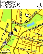
Ein Ausschnitt der Openstreetmapkarte auf einem GPS-Gerät. Der Ausschnitt zeigt den Innenstadtbereich von Frankfurt am Main.
- This media file was uploaded by author of the work and its copyright holder.
![]()
![]()
![]()
This work is licensed under the Creative Commons Attribution-ShareAlike 4.0 License.
Attribution: Computerteddy
Attribution: Computerteddy
![]()
Contains map data © OpenStreetMap contributors, made available under the terms of the Creative Commons Attribution-ShareAlike 2.0 (CC-BY-SA-2.0).
File history
Click on a date/time to view the file as it appeared at that time.
| Date/Time | Thumbnail | Dimensions | User | Comment | |
|---|---|---|---|---|---|
| current | 18:40, 16 August 2007 | | 176 × 220 (32 KB) | Computerteddy (talk | contribs) | Ausschnitt der Frankfurter Innenstadt auf meinem GPS |
| 18:59, 10 July 2007 |  | 612 × 816 (145 KB) | Computerteddy (talk | contribs) | Ein Ausschnitt der Openstreetmapkarte auf einem GPS-Gerät. Der Ausschnitt zeigt den Innenstadtbereich von Frankfurt am Main. |
You cannot overwrite this file.
File usage
The following page uses this file: