File:GroundTruth Collage.png
Jump to navigation
Jump to search


Size of this preview: 800 × 529 pixels. Other resolutions: 320 × 212 pixels | 640 × 423 pixels | 1,024 × 677 pixels | 1,322 × 874 pixels.
Original file (1,322 × 874 pixels, file size: 390 KB, MIME type: image/png)
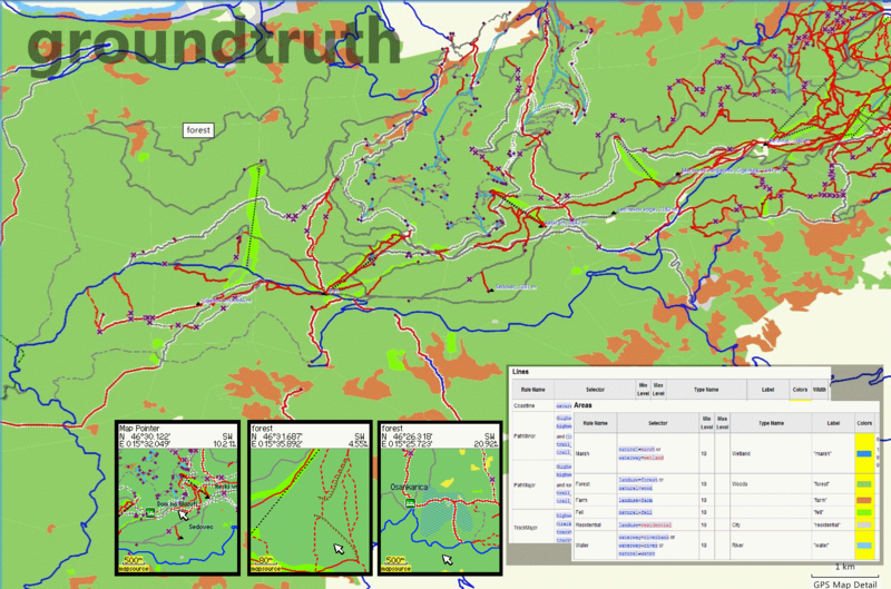
A collage of various screenshots of GroundTruth software - MapSource, Garmin unit and Wiki pages
This is a Featured image, which means that it has been identified as one of the best examples of OpenStreetMap mapping, or that it provides a useful illustration of the OpenStreetMap project. If you know another image of similar quality, you can nominate it on Featured image proposals.
Front-page image for week 11 of 2009 (9–15 Mar.).
- Image descriptions
- English : GroundTruth is a new mapmaking tool for converting OSM data into Garmin maps. This featured image is a collage of various screenshots taken from MapSource, a Garmin unit and from Wiki pages containing rendering rules.
- italiano : GroundTruth è un nuovo strumento per creare mappe che converte i dati OSM into mappe Garmin. Questa immagine è un collage di varie schermate prese da MapSource, da una unità Garmin, dalle pagine del Wiki che contengono le regole di vestizione.
- português : GroundTruth é a nova ferramenta de mapeamento para converter dados OSM em mapas Garmin. A imagem mostra uma colagem de várias capturas de tela tiradas do MapSource, um Garmin e das páginas Wiki contendo as regras de renderização.
File history
Click on a date/time to view the file as it appeared at that time.
| Date/Time | Thumbnail | Dimensions | User | Comment | |
|---|---|---|---|---|---|
| current | 22:05, 27 January 2009 | | 1,322 × 874 (390 KB) | Breki (talk | contribs) | A collage of various screenshots of GroundTruth software - MapSource, Garmin unit and Wiki pages |
You cannot overwrite this file.