File:Kharkiv dark wiki.png

Original file (2,007 × 2,007 pixels, file size: 8.78 MB, MIME type: image/png)
Summary
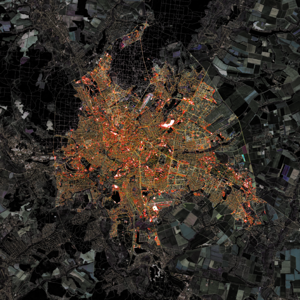
Kharkiv (Ukrainian : Харкiв) or Kharkov (Russian : Харьков) autumn. Dark Edition. Scale 1: 300,000.
Cartographic design artwork from the series "Cities in the fall. Light and Dark Edition".
I'm creating cartographic design artwork using open source tools QGIS, GDAL, and using data from Landsat 8 satellite image and Openstreetmap data (October 2017).
This artwork was posted in my account (Gontsa) in Instagram as part of my portfolio and demonstration of open source cartographic tools.

Front-page image for week 44 of 2017 (30 Oct. – 5 Nov.).
- Image descriptions
- English : Gontsa is creating a series of images merging OpenStreetMap data on top of Landsat satellite imagery. This image shows Kharkiv, Ukraine, during the autumn. You can see other works of Gontsa on his Instagram page.
- français : Gontsa a créé une série d’images qui fusionnent des données d’OpenStreetMap au dessus d’images par satellite Landsat. Cette image montre la ville de Kharkiv en Ukraine, durant l’automne. Vous pouvez voir d’autres œuvres de Gontsa sur sa page Instagram.
- italiano : Gontsa sta creando una serie di immagini che fondono i dati di OpenStreetMap sulle immagini del satellite Landsat. Questa immagine mostra Kharkiv, Ucraina, durante l'autunno. Si possono vedere altre opere di Gontsa nella sua pagina su Instagram.
- українська : Gontsa створив серію зображень поєднавши дані OpenStreetMap та супутникові знімки Landsat. На цій світлині Харків, Україна, восени. Ви можете ознайомитись з іншими роботами Gontsa відвідавши його сторінку в Instagram.
- 中文(简体) : Gontea创造一列列运用开放街图资料与叠上 Landsat 卫星影像的图片。这张图显示乌克兰卡尔可夫秋天的图像。更多图片可到Gontea 的 Instagram 页面观赏。
- 中文(繁體) : Gontea創造一列列運用開放街圖資料與疊上 Landsat 衛星影像的圖片。這張圖顯示烏克蘭卡爾可夫秋天的圖像。更多圖片可到Gontea 的 Instagram 頁面觀賞。
Licensing
![]()
![]()
![]()
Attribution not specified as a parameter! THIS LICENSE ALWAYS REQUIRES ATTRIBUTION! Use {{CC-BY-SA-3.0|Attribution, typically name of author}} See Template:CC-BY-SA-3.0 for full description how this template should be used.
File history
Click on a date/time to view the file as it appeared at that time.
| Date/Time | Thumbnail | Dimensions | User | Comment | |
|---|---|---|---|---|---|
| current | 10:16, 9 October 2017 | | 2,007 × 2,007 (8.78 MB) | Gontsa (talk | contribs) | Kharkiv autumn. Dark Edition. Scale 1: 300,000 Cartographic design artwork from the series "Cities in the fall. Light and Dark Edition". I'm creating cartographic design artwork using open source tools QGIS, GDAL, and using data from Landsat 8 satellit... |
You cannot overwrite this file.
File usage
The following 14 pages use this file:
- Featured images/Oct-Dec 2017
- List of featured images/2017
- Pt:Featured images/Oct-Dec 2017
- Uk:Featured images/Oct-Dec 2017
- Zh-hans:Featured images/Oct-Dec 2017
- Zh-hant:Featured images/Oct-Dec 2017
- User:Gontsa
- Template:Iotw image/2017-44
- DE:Featured images/Oct-Dec 2017
- FR:Featured images/Oct-Dec 2017
- ES:Imágenes destacadas/Oct-Dic 2017
- IT:Featured images/Oct-Dec 2017
- RU:Featured images/Oct-Dec 2017
- JA:Featured images/Oct-Dec 2017