File:Penza mapping party 2021-02-20...03-31 timeline.en.png
Jump to navigation
Jump to search
Size of this preview: 800 × 565 pixels. Other resolutions: 320 × 226 pixels | 640 × 452 pixels | 1,024 × 723 pixels | 1,280 × 904 pixels | 2,560 × 1,807 pixels | 8,500 × 6,000 pixels.
Original file (8,500 × 6,000 pixels, file size: 1.27 MB, MIME type: image/png)
The image is also available in Russian
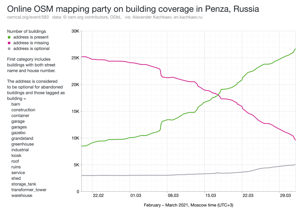
Context: osmcal.org/event/583
See also: timeline extension
Green line represents buildings with addresses, i.e. ways or relations with addr:street/addr:place and addr:housenumber.
Red line represents buildings that lack address tags.
Gray line represents buildings of certain types, for which it is rare to have addresses in the real world (sheds, garages, etc.). If the address for such building is present, it is moved to first category.
Licensing
![]()
This file has been released into the public domain by the copyright holder, its copyright has expired, or it is ineligible for copyright. This applies worldwide.
Please, please use more specific template such as {{PD-self}} / {{PD-creator}} / {{PD-shape}} / {{PD-USGov}} / {{PD-old}} / {{PD-RU-exempt}} ... This template is not making clear why this work is in the public domain.
Please, please use more specific template such as {{PD-self}} / {{PD-creator}} / {{PD-shape}} / {{PD-USGov}} / {{PD-old}} / {{PD-RU-exempt}} ... This template is not making clear why this work is in the public domain.
File history
Click on a date/time to view the file as it appeared at that time.
| Date/Time | Thumbnail | Dimensions | User | Comment | |
|---|---|---|---|---|---|
| current | 12:05, 17 April 2021 | | 8,500 × 6,000 (1.27 MB) | Kachkaev (talk | contribs) | Fix typo (viz → vis) |
| 08:54, 11 April 2021 |  | 8,500 × 6,000 (1.27 MB) | Kachkaev (talk | contribs) |
You cannot overwrite this file.
File usage
The following page uses this file: