File:Sinj osm map 800px.JPG
Jump to navigation
Jump to search


Size of this preview: 422 × 599 pixels. Other resolutions: 169 × 240 pixels | 338 × 480 pixels.
Original file (800 × 1,135 pixels, file size: 562 KB, MIME type: image/jpeg)
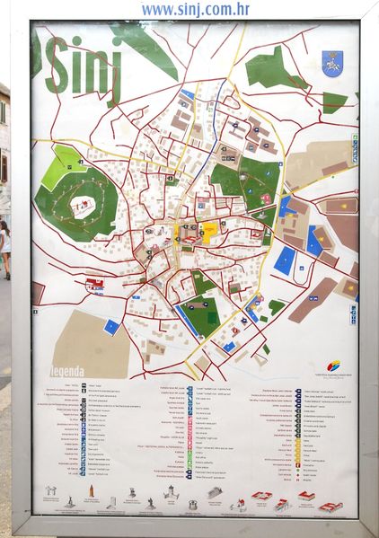
Sinj in Crotia. On OSM-map and Wikipedia.
This is a Featured image, which means that it has been identified as one of the best examples of OpenStreetMap mapping, or that it provides a useful illustration of the OpenStreetMap project. If you know another image of similar quality, you can nominate it on Featured image proposals.
Front-page image for week 32 of 2010 (9–15 Aug.).
- Image descriptions
- Deutsch : Jhabjan's Karte von Sinj in Kroatien, erstellt für das Tourismusbüro. Luftbilder wurden vom lokalen Luftfahrtclub gespendet.
- English : Jhabjan's map of Sinj in Croatia, printed for tourism office. Aerial images were donated by local aerial club.
- français : Carte réalisée par Jhabjan de la ville de Sinj en Croatie, imprimée pour l'office du tourisme. Images aériennes données par le club aérien local.
- hrvatski : Jhabjanova karta grada Sinja, tiskana za turističku zajednicu. Zračne fotografije je donirao lokalni avio klub.
- italiano : La mappa creata da Jhabjan della città di Signo in Croazia, stampata per l'ufficio turistico. Le immagini aeree sono state donate dall'aero club locale.
- lietuvių : Vartotojo Jhabjan sugeneruotas miesto Sinj(Kroatija) žemėlapis, atspausdintas turizmo biurui. Nuotraukas suteikė vietos oro klubas.
- Nederlands : Jhabjan's kaart van Sinj in Croatia, geprint voor het lokale toerisme bureau. Een lokale vliegvereniging heeft voor luchtfotografie gezorgd.
- polski : Plan miasteczka Sinj w Chorwacji autorstwa Jhabijana wydrukowany dla biura informacji turystycznej. Zdjęcia lotnicze zostały podarowane przez lokalny aeroklub.
- português : Mapa do usuário Jhabjan, de Sinj, na Croácia, impresso para um escritório de turismo. Imagens aéreas foram doadas pelo clube aéreo local.
- русский : Карта города Синь (Sinj) в Хорватии, напечатанная участником Jhabjan для туристического бюро. Спутниковые снимки были оплачены местным клубом.
- 中文(简体) : 克罗地亚 Sinj 的地图,由 Jhabjan 绘制,航空图像由当地空中俱乐部捐献。
File history
Click on a date/time to view the file as it appeared at that time.
| Date/Time | Thumbnail | Dimensions | User | Comment | |
|---|---|---|---|---|---|
| current | 10:44, 28 July 2010 | | 800 × 1,135 (562 KB) | ValentTurkovic (talk | contribs) |
You cannot overwrite this file.
File usage
The following 9 pages use this file: