File:Square-mile-street-networks.jpg
Jump to navigation
Jump to search


Size of this preview: 747 × 600 pixels. Other resolutions: 299 × 240 pixels | 598 × 480 pixels | 957 × 768 pixels | 1,276 × 1,024 pixels | 1,973 × 1,584 pixels.
Original file (1,973 × 1,584 pixels, file size: 898 KB, MIME type: image/jpeg)
Summary
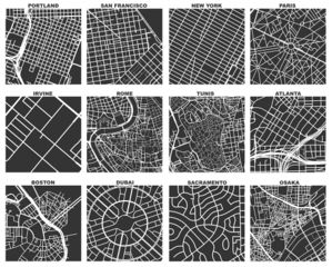
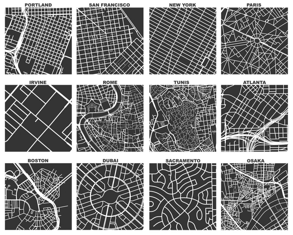
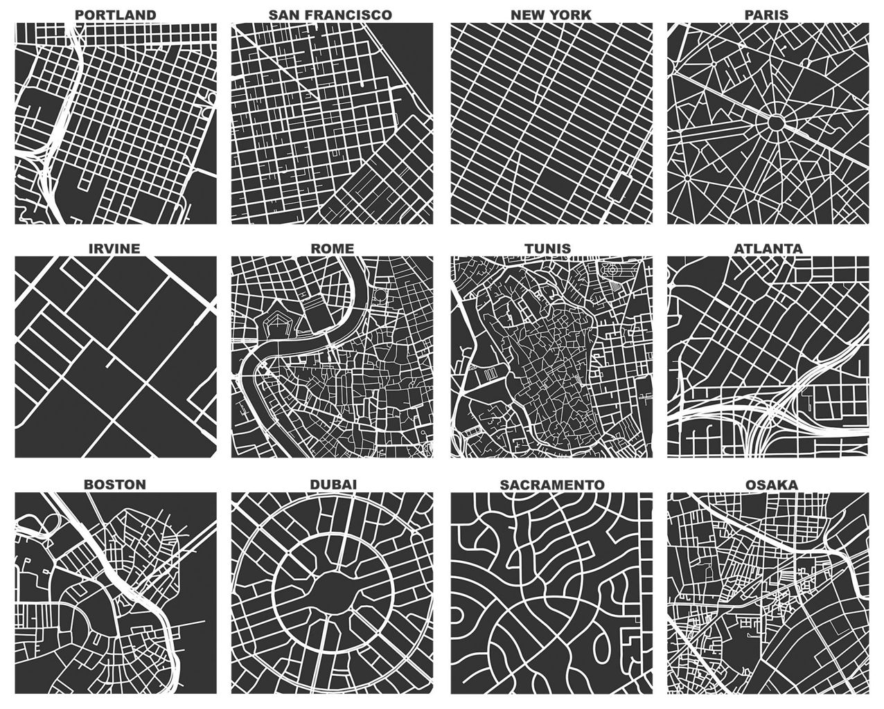
Geoff Boeing created OSMnx, a software that uses OSM data to compare street networks and urban forms. See more at: http://geoffboeing.com/2017/04/urban-form-analysis-openstreetmap/
This is a Featured image, which means that it has been identified as one of the best examples of OpenStreetMap mapping, or that it provides a useful illustration of the OpenStreetMap project. If you know another image of similar quality, you can nominate it on Featured image proposals.
Front-page image for week 16 of 2017 (17–23 Apr.).
- Image descriptions
- English : Geoff Boeing created OSMnx, a tool which uses OSM data to compare street networks and urban forms. In the image you can see one square mile extracts of some city centers around the world. Read more about Geoff's work on his blog.
- français : Geoff Boeing a créé OSMnx, un outil qui utilise les données OSM pour comparer les réseaux de rues et formes urbaines. Dans l’image vous pouvez voir des extraits carrés d’un mille de côté du centre de quelques villes dans le monde. Pour en savoir plus sur les travaux de Geoff, lisez son blogue.
- italiano : Geoff Boeing ha creato OSMnx, uno strumento che usa i dati di OSM per confrontare le reti stradali e le forme urbane. Nell'immagine si possono vedere degli estratti quadrati di un miglio di lato dei centri di alcune città nel mondo. Per ulteriori informazioni sul lavoro di Geoff consultare il suo blog.
- 中文(简体) : Geoff Boeing 创造工具 OSMnx,能够藉由分析 OSM 资料,比较不同城市的道路网和都会区型态。在图片中你能看到一英里见方尺度,世界不同城市中心的资料截取。到 Geoff 部落格阅读更多关于 Geoff 作品的资讯。
- 中文(繁體) : Geoff Boeing 創造工具 OSMnx,能夠藉由分析 OSM 資料,比較不同城市的道路網和都會區型態。在圖片中你能看到一英里見方尺度,世界不同城市中心的資料截取。到 Geoff 部落格閱讀更多關於 Geoff 作品的資訊。
Licensing
![]()
![]()
![]()
This work is licensed under the Creative Commons Attribution-ShareAlike 3.0 License.
Attribution not specified as a parameter! THIS LICENSE ALWAYS REQUIRES ATTRIBUTION! Use {{CC-BY-SA-3.0|Attribution, typically name of author}} See Template:CC-BY-SA-3.0 for full description how this template should be used.
Attribution not specified as a parameter! THIS LICENSE ALWAYS REQUIRES ATTRIBUTION! Use {{CC-BY-SA-3.0|Attribution, typically name of author}} See Template:CC-BY-SA-3.0 for full description how this template should be used.
File history
Click on a date/time to view the file as it appeared at that time.
| Date/Time | Thumbnail | Dimensions | User | Comment | |
|---|---|---|---|---|---|
| current | 12:48, 16 April 2017 | | 1,973 × 1,584 (898 KB) | Wille (talk | contribs) | Geoff Boeing created OSMnx, a software that uses OSM data to compare street networks and urban forms. See more at: http://geoffboeing.com/2017/04/urban-form-analysis-openstreetmap/ |
You cannot overwrite this file.
File usage
The following 15 pages use this file:
- Featured images/Apr-Jun 2017
- List of featured images/2017
- OSMnx
- Pt:Featured images/Apr-Jun 2017
- Uk:Featured images/Apr-Jun 2017
- Zh-hans:Featured images/Apr-Jun 2017
- Zh-hant:Featured images/Apr-Jun 2017
- Template:Featured image d2
- Template:Iotw image/2017-16
- DE:Featured images/Apr-Jun 2017
- FR:Featured images/Apr-Jun 2017
- ES:Imágenes destacadas/Abr-Jun 2017
- IT:Featured images/Apr-Jun 2017
- RU:Featured images/Apr-Jun 2017
- JA:Featured images/Apr-Jun 2017