Zh-hans:Featured images/Apr-Jun 2017
Jump to navigation
Jump to search


这是特色图片,展现开放街图画地图范例,以及最能代表开放街图的专案。
如果你知道其他有类似品质的图片,你可以在特色图片提名处(en)提名。
| ← 从2016年4月到6月 | ← 从2017年1月到3月 | 从2017年7月到9月 → | 从2018年4月到6月 → |
特色图片库、从2017年4月到6月

2017年、第14周
2017年、第15周

2017年、第16周
2017年、第17周
2017年、第18周
2017年、第19周

2017年、第20周
2017年、第21周

2017年、第22周

2017年、第23周
2017年、第24周

2017年、第25周
2017年、第26周
细节和字幕
第14周(从2017年4月3日星期一到2017年4月9日星期日) [Edit]

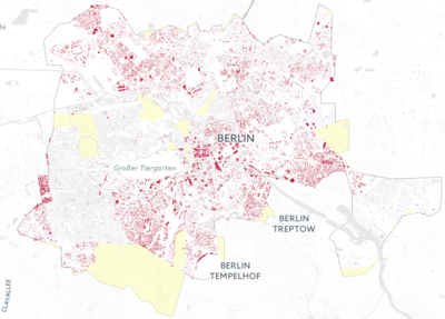
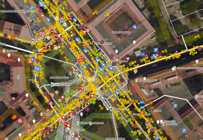
- English : Illustrating the scale of destruction in Aleppo, Syria, by reprojecting it onto OpenStreetMap buildings of Berlin: hanshack.com.
- 中文(简体) : 藉由将建筑投影到柏林的地图上,视觉化叙利亚阿勒坡的建筑毁损程度:hanshack.com。
第15周(从2017年4月10日星期一到2017年4月16日星期日) [Edit]

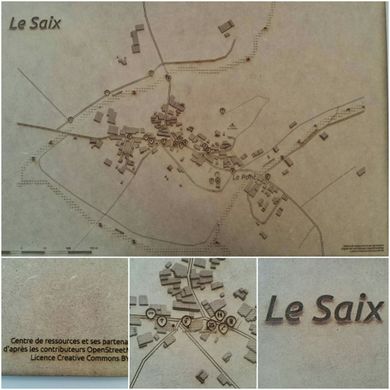
- English : The village of Le Saix (Hautes-Alpes, France) mapped in OpenStreetMap [1] and printed with a laser cutter. A collaboration between Centre de ressources, Apitux, Camille Bissuel and Planète Champsaur, made in Fab'Alpes in Gap.
- 中文(简体) : 勒赛村庄(法国上阿尔卑斯省)在开放街图的绘制状况 ([2]),用雷射切割机列印出来。这是Centre de ressources、Apitux、Camille Bissuel 和 Planète Champsaur 之间合作的成果,由Fab'Alpes in Gap 制作。
第16周(从2017年4月17日星期一到2017年4月23日星期日) [Edit]

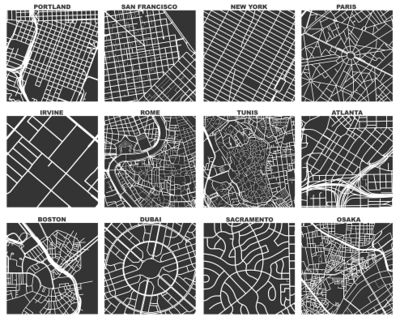
- English : Geoff Boeing created OSMnx, a tool which uses OSM data to compare street networks and urban forms. In the image you can see one square mile extracts of some city centers around the world. Read more about Geoff's work on his blog.
- 中文(简体) : Geoff Boeing 创造工具 OSMnx,能够藉由分析 OSM 资料,比较不同城市的道路网和都会区型态。在图片中你能看到一英里见方尺度,世界不同城市中心的资料截取。到 Geoff 部落格阅读更多关于 Geoff 作品的资讯。
第17周(从2017年4月24日星期一到2017年4月30日星期日) [Edit]

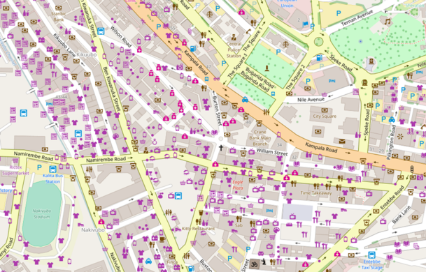
- English : In 2017 we will have the first ever State of the Map Africa! It will be held in Kampala, Uganda’s capital, from 8th to 10th July. Here we see the well mapped Kampala city centre.
- 中文(简体) : 2017 年我们将有首次举行的 State of the Map Africa!这次会议将在乌干达首都坎帕拉举行,时间是 7 月 8 日至 10 日。我们可以看到画得相当详尽的坎帕拉城市中心。
第18周(从2017年5月1日星期一到2017年5月7日星期日) [Edit]

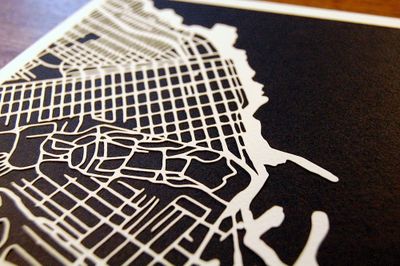
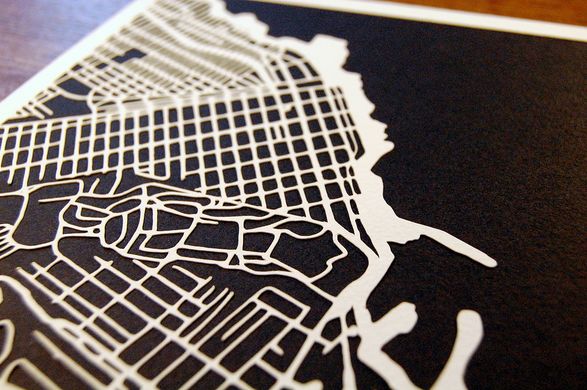
- English : Kartegraphik has been doing handmade papercut maps based on OpenStreetMap data. This image is a map of Monterey, California. See more at kartegraphik.com.
- 中文(简体) : Kartegraphik 运用开放街图资料制作手工剪纸地图,这张图片是加州蒙特雷的地图。kartegraphik.com 阅读更多资讯。
第19周(从2017年5月8日星期一到2017年5月14日星期日) [Edit]

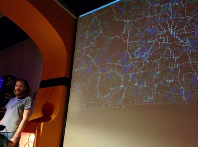
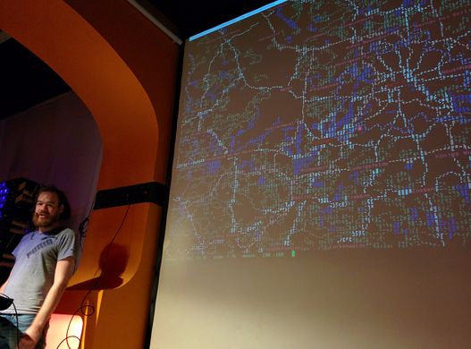
- English : A presentation of mapscii [3], a zooming panning view of OpenStreetMap rendered as ASCII art (also including Braille dot patterns).
- 中文(简体) : 将开放街图算绘成 ASCII 艺术风格,可缩放、平移地图 mapscii [4] 的简报 (当然也有包括盲文点阵图案)。
第20周(从2017年5月15日星期一到2017年5月21日星期日) [Edit]

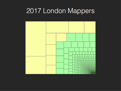
- English : The top ten mappers (yellow) account for most of the data contributed in London so far in 2017. Andy Allan presented "Who is mapping London?" at the recent OSM Q&A event.
- 中文(简体) : 截至 2017 年为止伦敦一带资料贡献前十名的图客帐号 (黄)。Andy Allan 在最近一次的 OSM Q&A event 报告 "Who is mapping London?"
第21周(从2017年5月22日星期一到2017年5月28日星期日) [Edit]

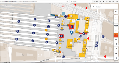
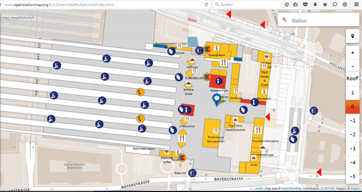
- English : Large railway stations often include shops and other features inside them. OpenStationMap (openstationmap.org) reveals indoor mapping data (where it has been added) specifically for railway stations.
- 中文(简体) : 大型火车站里常包括商店和其他图征。OpenStationMap (openstationmap.org) 能显示火车站室内地图资料 (只要有人加资料的话)。
第22周(从2017年5月29日星期一到2017年6月4日星期日) [Edit]

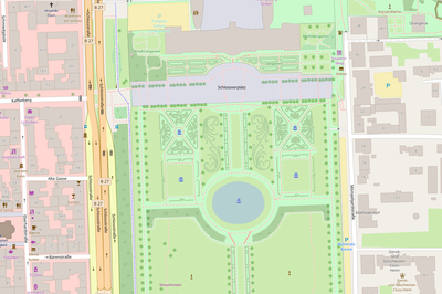
- English : Nammala from the Mapbox data team gave a round-up of some recent interesting edits, mostly vandalism detected using osmcha, but also this very detailed mapping of the Gardens of Ludwigsburg Palace made by Paddy1984.
- 中文(简体) : Mapbox 资料团队的 Nammala 记录最近一些有趣的编辑,大部分是 osmcha 侦测到的破坏,但也有 Paddy1984 绘制相当详尽的路德维希堡宫花园。
第23周(从2017年6月5日星期一到2017年6月11日星期日) [Edit]
.jpg)
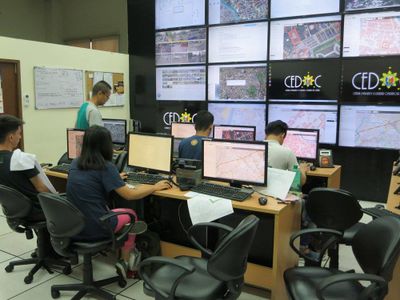
- English : Mapathons can be made more fun and interesting when your work is displayed on a wall of monitors for everyone to see! This mapathon, supported by the OSM Philippines community, was organized by User:GOwin as part of his MapAmore initiative and was hosted by the City of San Juan's Central Emergency and Disaster Operations Center (CEDOC).
- 中文(简体) : 如果举行图客趴时能在整墙的萤幕上看到你的成果一定会更有趣!这次图客趴由仙范市中央紧急和灾害行动中心 (Central Emergency and Disaster Operations Center, CEDOC) 举行,由 User:GOwin 统寿,属于 MapAmore initiative 的一部分活动。
第24周(从2017年6月12日星期一到2017年6月18日星期日) [Edit]

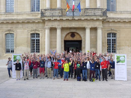
- English : Some of the 250 attendees of State of the Map France 2017, which took place 2–4 June in Avignon.
- 中文(简体) : State of the Map France 2017 大会上其中 250 位参与者,这场会议 6 月 2~4 日在亚维侬举行。
第25周(从2017年6月19日星期一到2017年6月25日星期日) [Edit]

- English : The iD editor showing a new data layer from Mapillary, with road signs detected within the street-level imagery.
- 中文(简体) : iD 编辑器显示来自 Mapillary 新的资料图层,能够用街景层级的图片侦测里面的道路方向指标。
第26周(从2017年6月26日星期一到2017年7月2日星期日) [Edit]
