File:Standard style change Oct 2015 before and after.png
Jump to navigation
Jump to search


Size of this preview: 799 × 600 pixels. Other resolutions: 320 × 240 pixels | 639 × 480 pixels | 807 × 606 pixels.
Original file (807 × 606 pixels, file size: 717 KB, MIME type: image/png)
Summary
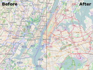
before and after illustration of the change to the "standard" style taking place October 2015 blog.
It's showing New York at zoom level11: http://www.openstreetmap.org/#map=11/40.7418/-74.0046
This is a Featured image, which means that it has been identified as one of the best examples of OpenStreetMap mapping, or that it provides a useful illustration of the OpenStreetMap project. If you know another image of similar quality, you can nominate it on Featured image proposals.
Front-page image for week 45 of 2015 (2–8 Nov.).
- Image descriptions
- Bahasa Indonesia : 'Standar' gaya OpenStreetMap baru-baru ini berubah untuk mewakili jenis jalan-jalan utama dengan perkembangan mantap hue dan ringan, membantu untuk membuat mereka terlihat lebih lainnya warna jenis tanah. Baca lebih lanjut di blog
- English : The 'standard' OpenStreetMap style was recently changed to represent major roads types with a steady progression of hue and lightness, helping to make them visible over other land types colour. Read more on the blog
- italiano : Lo stile "standard" di OpenStreetMap è stato recentemente modificato per rappresentare i principali tipi di strada con una progressione continua di tonalità e luminosità che aiuta a renderle più visibili sopra agli altri colori usati per i tipi di terreno. Maggiori informazioni in inglese nel blog.
- русский : Обновился стандартный стиль карты. Дороги разных категорий теперь обозначены последовательностью похожих цветов, что делает их легко отличимыми от других объектов. Подробности в блоге.
- 中文(简体) : 最近'标准'的开放街图地图样式大改变,更动彩度和亮度,以便让主要道路能够跟土地利用的颜色区别。欲知详情请看部落格文章
- 中文(繁體) : 最近'標準'的開放街圖地圖樣式大改變,更動彩度和亮度,以便讓主要道路能夠跟土地利用的顏色區別。欲知詳情請看部落格文章
Licensing
| Contains map data © OpenStreetMap contributors, made available under the terms of the Open Database License (ODbL).
The ODbL does not require any particular license for maps produced from ODbL data, produced maps may be subject also to other licences. |
File history
Click on a date/time to view the file as it appeared at that time.
| Date/Time | Thumbnail | Dimensions | User | Comment | |
|---|---|---|---|---|---|
| current | 11:53, 2 November 2015 | | 807 × 606 (717 KB) | Harry Wood (talk | contribs) | Update with a later version of the new style as it was actually deployed (see the rectangular highway labels) |
| 23:00, 31 October 2015 | 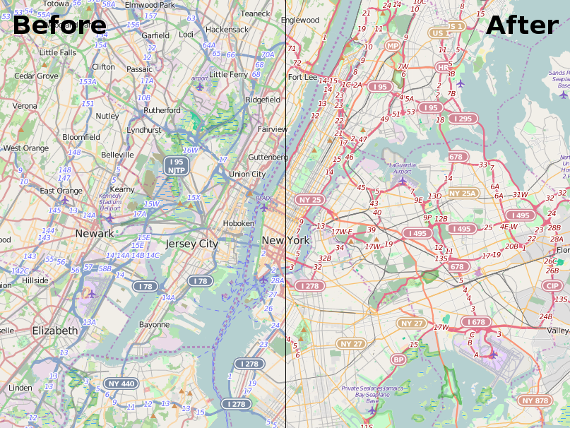 | 807 × 606 (835 KB) | Harry Wood (talk | contribs) | before and after illustration of the change to the "standard" style taking place October 2015 [https://blog.openstreetmap.org/2015/10/30/openstreetmap-org-map-changing/ blog]. |
You cannot overwrite this file.
File usage
The following 7 pages use this file: