File:StolenRide.jpg
Jump to navigation
Jump to search


Size of this preview: 800 × 543 pixels. Other resolutions: 320 × 217 pixels | 640 × 434 pixels | 890 × 604 pixels.
Original file (890 × 604 pixels, file size: 108 KB, MIME type: image/jpeg)
Summary
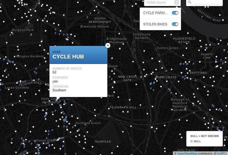
A map made by Stolen Ride shows every London cycle parking location mapped on OpenStreetMap and an optional layer of police data with the places of reported stolen bikes.
This is a Featured image, which means that it has been identified as one of the best examples of OpenStreetMap mapping, or that it provides a useful illustration of the OpenStreetMap project. If you know another image of similar quality, you can nominate it on Featured image proposals.
Front-page image for week 46 of 2017 (13–19 Nov.).
- Image descriptions
- asturianu : Un mapa fechu por Stolen Ride amuesa tolos llugares d'aparcamientu de bicicletes de Londres del mapa d'OpenStreetMap, xunto con una capa opcional de datos de la policía con los llugares de los robos denunciaos de bicicletes.
- English : A map made by Stolen Ride shows every London cycle parking location mapped on OpenStreetMap and an optional layer of police data with the places of reported stolen bikes.
- français : Une carte réalisée par Stolen Ride montre tous les emplacements de stationnement de vélos à Londres cartographiés sur OpenStreetMap ainsi qu’un calque des données de la police sur les lieux où des vélos ont été signalés volés.
- italiano : Una mappa creata da Stolen Ride mostra la posizione di ogni parcheggio per biciclette di Londra mappato su OpenStreetMap e un layer opzionale di dati della polizia con i luoghi dove sono stati denunciati furti di biciclette.
- 中文(简体) : Stolen Ride 制作的地图显示每个画上开放街图的伦敦单车停车位置,以及可以选择打开的图层,显示警方的被窃单车报告位置。
- 中文(繁體) : Stolen Ride 製作的地圖顯示每個畫上開放街圖的倫敦單車停車位置,以及可以選擇打開的圖層,顯示警方的被竊單車報告位置。
Licensing
![]()
![]()
![]()
This work is licensed under the Creative Commons Attribution-ShareAlike 2.0 License.
Attribution not specified as a parameter! THIS LICENSE ALWAYS REQUIRES ATTRIBUTION! Use {{CC-BY-SA-2.0|Attribution, typically name of author}} See Template:CC-BY-SA-2.0 for full description how this template should be used.
Note, there is
There is also
Attribution not specified as a parameter! THIS LICENSE ALWAYS REQUIRES ATTRIBUTION! Use {{CC-BY-SA-2.0|Attribution, typically name of author}} See Template:CC-BY-SA-2.0 for full description how this template should be used.
Note, there is
{{CC-BY-SA-2.0 OpenStreetMap}} for files based on old OSM map data, before the license change made on 2012-09-12.There is also
{{OSM Carto screenshot||old_license}} for files based on old OSM map data, before the license change made on 2012-09-12, created using OSM Carto map style.
File history
Click on a date/time to view the file as it appeared at that time.
| Date/Time | Thumbnail | Dimensions | User | Comment | |
|---|---|---|---|---|---|
| current | 19:08, 26 September 2017 | | 890 × 604 (108 KB) | Wille (talk | contribs) | A [map made by Stolen Ride https://www.stolenride.co.uk/cycle-parking-map-london/] shows every London cycle parking location mapped on OpenStreetMap and an optional layer of police data with the places of reported stolen bikes. |
You cannot overwrite this file.
File usage
The following 13 pages use this file:
- Featured images/Oct-Dec 2017
- List of featured images/2017
- Pt:Featured images/Oct-Dec 2017
- Uk:Featured images/Oct-Dec 2017
- Zh-hans:Featured images/Oct-Dec 2017
- Zh-hant:Featured images/Oct-Dec 2017
- Template:Iotw image/2017-46
- DE:Featured images/Oct-Dec 2017
- FR:Featured images/Oct-Dec 2017
- ES:Imágenes destacadas/Oct-Dic 2017
- IT:Featured images/Oct-Dec 2017
- RU:Featured images/Oct-Dec 2017
- JA:Featured images/Oct-Dec 2017