File:World-gps-points-120604-2048.png
Jump to navigation
Jump to search


Size of this preview: 800 × 500 pixels. Other resolutions: 320 × 200 pixels | 640 × 400 pixels | 1,024 × 640 pixels | 1,280 × 800 pixels | 2,048 × 1,280 pixels.
Original file (2,048 × 1,280 pixels, file size: 1.56 MB, MIME type: image/png)
Summary
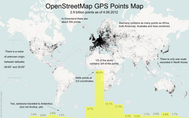
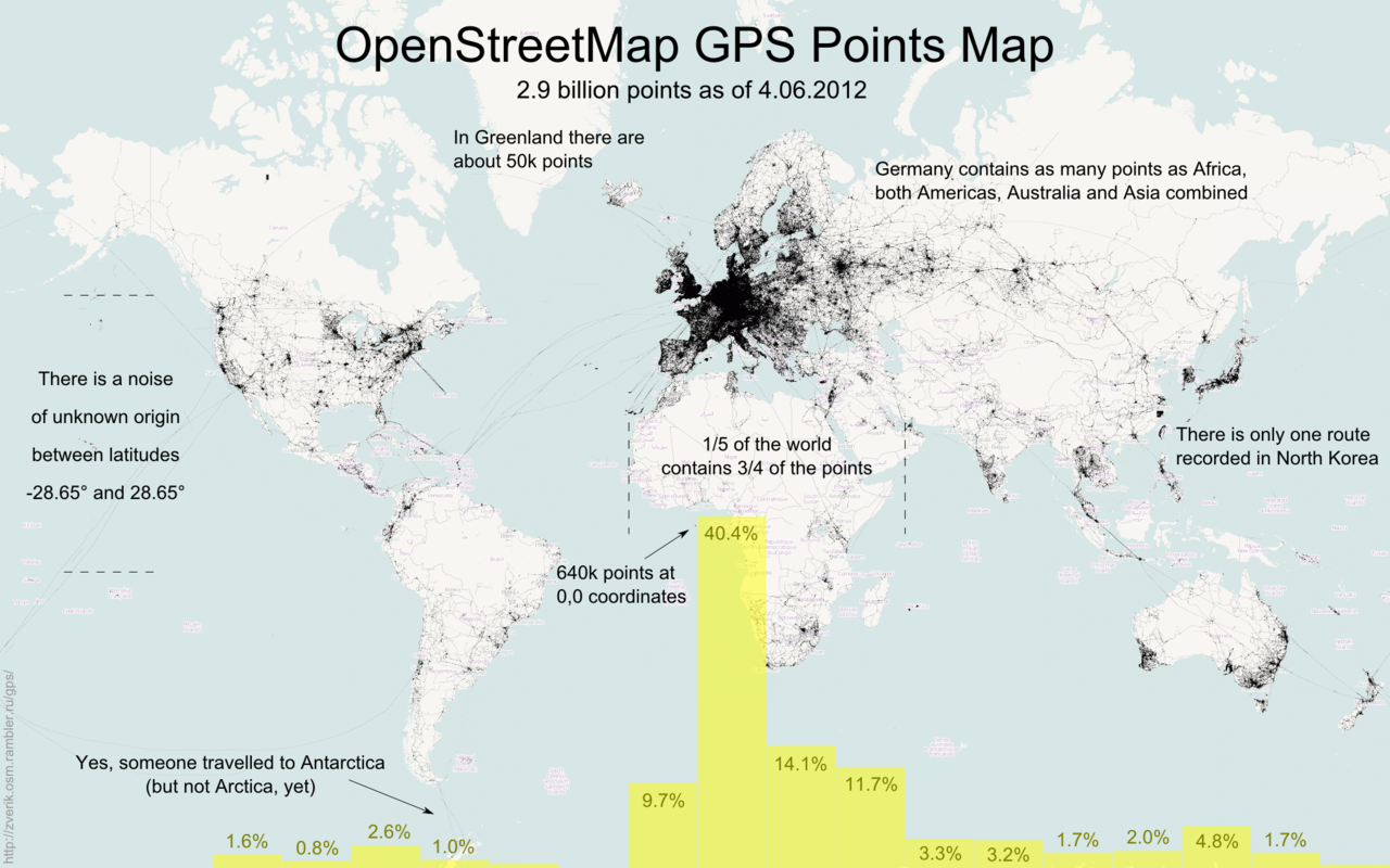
Visualization of the Planet.gpx dump with some commentary
Licensing
This is a Featured image, which means that it has been identified as one of the best examples of OpenStreetMap mapping, or that it provides a useful illustration of the OpenStreetMap project. If you know another image of similar quality, you can nominate it on Featured image proposals.
Front-page image for week 38 of 2012 (17–23 Sep.).
- Image descriptions
- Deutsch : Visualisierung der GPX-Daten mit einigen Kommentare.
- English : Visualization of the Planet.gpx dump with some commentary.
- français : Visualisation du dump GPX accompagné de quelques commentaires.
- italiano : Visualizzazione del Planet.gpx con alcuni commenti.
- 中文(简体) : Planet.gpx dump 档案的资料视觉化,图上有说明文字。
- 中文(繁體) : Planet.gpx dump 檔案的資料視覺化,圖上有說明文字。
![]()
![]()
This file is made available under the Creative Commons CC0 1.0 Universal Public Domain Dedication.
Attribution: User:Zverik
Attribution: User:Zverik
The person who associated a work with this deed has dedicated the work to the public domain by waiving all of his or her rights to the work worldwide under copyright law, including all related and neighboring rights, to the extent allowed by law. You can copy, modify, distribute and perform the work, even for commercial purposes, all without asking permission.
File history
Click on a date/time to view the file as it appeared at that time.
| Date/Time | Thumbnail | Dimensions | User | Comment | |
|---|---|---|---|---|---|
| current | 06:30, 17 September 2012 | | 2,048 × 1,280 (1.56 MB) | Gnonthgol (talk | contribs) | Visualization of the GPX dump with some commentary |
You cannot overwrite this file.