JOSM/Plugins/ContourMerge
Jump to navigation
Jump to search
ContourMerge
provides a tool to merge the contours of adjacent areas.

The contourmerge plugin provides a tool to merge the contours of adjacent areas.
Attention
This tool - patchworking of areas - makes only sense, if the areas are directly dependent on each other.
This does not apply to water bodies like lakes and rivers (natural=water respectively waterway=riverbed) and nearby landuse (landuse=*) !
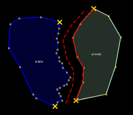
- Example
- Although forests can seemingly agree with the shore at a certain water level,
- when the water level drops, this will create a land area between forest and river that is not covered through forest
- when the water level rises, the trees would suddenly stand in the water ...
 |
|
 |
 |
This is mainly useful for mappers who trace areas like lakes, forests, riverbeds, residential areas, or other landuse areas from aerial imagery, i.e. from Bing.
News
| Date | News | Download |
|---|---|---|
| Mar 19, 2011 - 25618 |
(see changeset 25617) |
Open JOSM preferences and install plugin contourmerge |
| Feb 20, 2011 - 25380 | Fixed: unexpected intersections after drag-and-drop (see changeset 25379) | Open JOSM preferences and install plugin contourmerge |
| Jan 04, 2011 |
Initial version |
Open JOSM preferences and install plugin contourmerge |
Help and Howtos
Online help information and howtos are maintained on the JOSM wiki. You can access them from the contourmerge plugin by hovering over the map mode icon and pressing F1.