Minnesota/DakotaCounty/Buildings Import
Proposed project to import buildings with address attributes and building attributes relating to type (residential, commercial, etc)
Goals
Import Dakota County's building polygons that were collected using photogrammetry, after attributing them with address information from the address point database and with additional type information from their property data to enhance the map.
Data Background
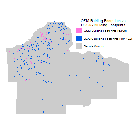
Dakota County's building polygon dataset has 164,492 features; sheds, housing, educational, commercial, government and industrial, etc.
Dakota County's address point dataset has 165,975 features.
OSM data (February 23, 2017) currently has 5,896 building polygons digitized. More than half (3,271) are simply tagged buiding:yes.
Schedule
Spring 2017
- Data assembly - completed March 2017
- Data chunk tiles defined - completed March 2017
- Data chucked
- to shp files - completed March 25, 2017
- converted to OSM files - open
- upload for user access - open
- Tasking Manager
- access - acquired March 20, 2017
- define project - April 3, 2017
- published - April 5, 2017
Spring 2020
- Data assembly - completed September 2019
- Data chunk tiles defined - completed September 2019
- Data chunked to OSM files - completed September 2019
- Tasking Manager
- project defined - April 4, 2020
- published - April 5, 2020
Import Data
Data Data source site and licensing - https://www.co.dakota.mn.us/HomeProperty/MappingServices/GISData/Pages/default.aspx
Import Type At this time this is proposed to be a one time import to greatly enhance the OSM database.
Sample Data Can be found on GitHub in the dakota-county-osm-building-import repository https://github.com/DcJoeS/dakota-county-osm-building-import
Data Preparation
Tagging
- addr:housenumber = BLDG_NUM from either parcel or address point data (if multiple address points exist a range for the building polygon will be created such as 123 - 127.
- addr:street = STREETNAME + STREETTYPE + SUFFIX_DIR from either parcel or address point data
- addr:city = CITY from either parcel or address point data
- addr:state = MN
- addr:postcode = ZIP from parcel data or ZIP5 from address point data
- addr:county = US
- name = LANDMARK from the parcel data
- building = as appropriate from USE1_DESC and DWELL_TYPE fields in parcel data below
- apartments = APARTMENT, APARTMENT-NURSHING HOME, RESIDENTIAL-CONDOMINIUM
- commercial = anything a wildcard search for commercial yields
- industrial = anything a wildcard search for industrial yields, MACHINERY, RAILROAD, UTILITIES
- house = APARTMENT-MOBILE HOME PARK, CABIN, RESIDENTIAL, RESIDENTIAL-TOWNHOUSE
- house = USE_DESC = EXEMPT AND XUSE1_DESC = a wildcard search for housing, shelter, convent, CDA (Community Development Agency - housing), benevolent
- farm = wildcard search for AG (agriculture)
- school = USE_DESC = EXEMPT AND XUSE1_DESC = a wildcard search for school
- church = USE_DESC = EXEMPT AND XUSE1_DESC = a wildcard search for church
- civic = USE_DESC = EXEMPT AND XUSE1_DESC = a wildcard search for Cit (City), Municipal, County, State, USA, Township, HWY, Metro (for government buildings) DNR (Department of Natural Resources
- university = USE_DESC = EXEMPT AND XUSE1_DESC = a wildcard search for College and University
- commercial = USE_DESC = EXEMPT AND XUSE1_DESC = a wildcard search for commercial
- hospital = USE_DESC = EXEMPT AND XUSE1_DESC = a wildcard search for hospital
- train_station = USE_DESC = EXEMPT AND XUSE1_DESC = a wildcard search for railroad
- garage = any building not tagged as one of the above that is greater than 500 square feet
- shed = everything else, because there is a really good chance it is and I'd rather start with shed and have someone change it than leave it yes/blank and open to further interpretation.
- building_levels = HOME_STYLE from parcel data, this is only for housing structures
- 1-1/2 STRY = 1
- 1-1/4 STRY = 1
- 1-3/4 STRY = 1
- ONE STORY = 1
- SPLIT LEVL = 2
- TWO STORY = 2
- TWO+ STORY = 2
Data Merge Workflow
Chunk the data by Public Land Survey (PLS) quarters. I looked at a few options that were census area based, but feedback that related to the shape of the areas pointed to it not be easy to "pan and scan" through and irregularly shape area. So a square or rectangle would be the best option. In some areas there may be a building the overlaps a section line, but that won't be too big of a deal.
Statistics
- PLS Quarters with buildings in them: 2,144
- Minimum number of buildings in a chunk: 1
- Maximum number of buildings in a chunk: 1481
- Mean number of buildings in a chunk: ~77
I merged a few quarter sections together, so there are a variety of quarter sections and full sections. This yielded:
- PLS Quarters or full sections with buildings in them: 1,311
- Minimum number of buildings in a chunk: 1
- Maximum number of buildings in a chunk: 1481
- Mean number of buildings in a chunk: ~126
This seems much better, few chunks to deal with and a little higher number of buildings for an editor to import, but nothing unmanageable.
There will be many areas that might be a "quick hit" for a novice or for someone with a just few minutes to contribute to editing. And a few areas with hundreds of buildings for someone with more time to contribute.
Project Team
DCJoeS more to come . . .
