Named spots instead of street names

|
| Description |
| In some countries (Japan, Korea, Nicaragua…), people orient themselves in the local area using the names of road junctions or traffic signals or reference points rather than the names of streets. |
| Tags |
|
name=* |
In some countries (Japan, Korea, Nicaragua…), people orient themselves in the local area using the names of road junctions or traffic signals or reference points (landmarks) rather than the names of streets. While street names may also exist, they are less important for orientation and navigation.
How to use
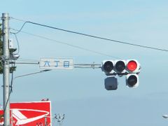
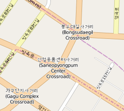
| Named road junctions (e. g. Korea) | Named traffic signals (e. g. Japan) | Named reference points (e. g. Nicaragua) | |
|---|---|---|---|
| What tag? | Use junction=yes together with a name=* tag. | Use highway=traffic_signals together with a name=* tag. | Use reference_point=yes together with a name=* tag. |
| On which element? | On simple crossroads, you tag simply the node that is shared by the crossing roads.
On complex road junctions, draw the area of the junction. This area has to share nodes with the incoming/outgoing highways. See the tag description for details. |
On simple situations, you tag simply the node that is shared by the crossing roads.
A tagging for more complex situations (dual carriageways etc.) has to be discussed. |
Use it on existing OSM elements that represent reference points. |
| Pitfalls | If you use junction=yes and highway=traffic_signals on the same node and if you have also a name=* tag, does the name tag belong to the junction or to the traffic signal? You can avoid this question by drawing the junction=yes as an area – independant of the node for the traffic signal. So you have 2 different elements: 1 for the junction and 1 for the traffic signals. | ||
Hints for software developers
If junction=yes and highway=traffic_signals are both present on the same element, than the name=* tag is more likely to be the name of the junction (and not of the traffic signal).
Hints for renderers
For renderers, it is reasonable to render all variants of this feature – junction names, traffic signal names, reference point names – with the same style (same font, same font colour, same font size), because in the end they represent the same feature. Usually the name is rendered as horizontal text (with line wrap). Some map styles draw also a rectangular border around it. It may be useful to use for this feature the same or a similar colour and font as for residential roads, because all this serves for orientation in the local area.
- For junction names, you would render usually only the name.
- For traffic signal names, you would render usually an icon for the traffic signal together with the name.
- For reference points, you would render usually the same way as if reference_point=yes were not present, but with one difference: The name is rendered with the font style of the feature “Named spots instead of street names”.
Please note that in Japan, on complex traffic signal systems, the name of the traffic signal system must get rendered only once (not multiple times). An appropriate tagging for this has to be discussed. Currently, you will find often various individual nodes (on the crossing OSM ways), each of them with highway=traffic_signals and the identical name=*.
