Nottingham/Pub Meetup
This is primarily a social event for East Midland mappers, but anyone who wishes to come & ask any kind of detailed question about OpenStreetMap is very welcome. We have a good range of experienced contributors who can usually give guidance on a wide range of OSM topics, from mapping to setting up a server. Typically we discuss a range of mapping issues in the first hour of the meeting.
We try and meet in pubs which meet a number of criteria, including: not too busy (making finding each other easier), availability of food (including vegetarian and, if possible, gluten free options), easily accessible by a range of public transport.
Despite its name and origins we are now aiming to form a nucleus for anyone in the East Midlands. To that end we now meet in Derby once a quarter (Feb, May, Aug and Nov), occasionally in Sheffield, and may meet elsewhere if an opportunity comes up.
Our NEXT Meeting will be in person on Tuesday 21sh February 2023 from 19:30 online on BigBlueButton.
Please note the earlier start time of 19:00, which gives people travelling from further afield a bit more time before sensible return trains leave.
| Local user group | |
| Nottingham Pub Meetup | |
| Meetings | |
| When: | monthly |
|---|---|
| Where: | The Brunswick, Derby, Map (map) |
| Mailing list | |
| no mailing list | |
| Website | |
| no website | |
| Image | |

| |
Who's coming?
Here's a list of people who will probably be attending. Do add your name to the list if you're interested. Alternatively you can sign-up for the event via OSMCal.
- edit the page to add your name here
Getting There
Check the venue for the given month.
If the pub is busy look for a table with GPS devices and possibly various OSM maps and/or paraphernalia. I have a(n old) logo which I hope to be able to put somewhere reasonably prominent. If all else fails you can call me (Jerry) on 077 9103 4742.
The Market Tavern, Chesterfield
Located in the market square close to the famous spire fo the parish church. A short (under 10 minute) walk from the station and even closer from the bus station. There is car parking at Holywell Cross ("The Doughnut"), at Rose Hill and possibly at others nearby (though check the closing time of multi-storeys).
Lincolnshire Poacher, Nottingham
The Lincolnshire Poacher is readily reached by a short walk (10 minutes), or a hot cycle ride (if on a Brompton) or by bus from the city centre, but is directly on bus routes from the North of the city.
There is parking in the immediate local area near The Arboretum (free across the road from 20:00). Bike parking is available just to the S of the pub: and is marked on OpenCyclemap. Recent experience suggests that this is not safe, many people take bikes into the back room of the pub or lock them up in the outdoor area.
The pub usually serves food, but there are a number of fast-food outlets nearby (some of dubious quality).
The Brunswick, Derby
The Brunswick is 200 metres from Derby railway station (turn right out of the main entrance and walk along Walkway Terrace). It's also about 600 metres from the bus station.
The railway station offers bicycle parking and car parking (£2 after 6pm).
The pub does not serve food on Tuesday evenings. There are a number of fast-food outlets in the immediate vicinity of the station.
Tap, Sheffield
At Sheffield railway station (in buildings at N end of platform 1), with Sheffield bus station across the road. Nearest tram stop is to the E of the station with access via the station footbridge (a public right of way).
The Tap does not do food, other than v. simple snacks, so in general we will try & meet in another pub first, and move to the Tap mid-evening to help ensure people catch their trains. At present we do not have a venue for this as our favoured location closed during the Covid pandemic.
Mapping Targets
Chesterfield
There are still some wholly unmapped sides of shopping streets in the town centre, and also the turnover of businesses at the "value" end is quite high, so a recheck of what's already mapped is welcome.
Local editors are working on capturing building outlines outside of the town centre. Quite a lot of new house building - both as new estates and in-fill buildings - local editors are working to complete street layouts on new estates.
Derby
There are still a few missing businesses in the centre of town, so a recheck of what's there wouldn't come amiss. Some industrial areas (Alfreton Road, Darley Abbey Mills) are also incomplete.
Many or most housing in the city is unmapped and unaddressed, so there's plenty to keep everyone busy there.
Area N of pub on E bank of Derwent near Little Chester looks a reasonable target for pre-pub mapping.
Nottingham
These are still fairly informal (at some stage I may start making cake slices). Currently the following look like interesting candidates:
- Continue address / house mapping in St Ann's (E of Corporation Oaks, Elm Avenue), specific target Sycamore neighbourhood (bounded by Robin Hood Chase, Abbotsford Road, Hungerhill Road, Gorsey Close Allotments & Woodborough Road):
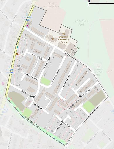
Known specific issues:
- Status of the two brownfield areas: former Sycamore Inn & immediately adjacent to Robin Hood Walk
- Is the social club still open; check status of convenience store.
- Check which footpaths actually link between buildings & which just give access to people's front-doors
- Establish pattern of location of doors in the large apartment/maisonette buildings. Usually there are doorways on both first & ground floors, and most buildings seem to have 3 apartments in each building section (visible on aerial images).
- Number of building levels, wall & roof materials
House numbers in Rose Close & odds at start of Hungerhill Road
- Status of footpaths behind 1-4 Rose Close.
- Check if some footpaths are actually service roads with car parking (esp on blocks next to Robin Hood Chase
- What is narrow building on Verbena Walk
- House numbers Lavender Walk (second part) and SE end of Lupin Close.
- Additional amenity trees (but not those on Robin Hood Chase)
In practice if there are 2-4 experienced mappers we may divide up to pursue these tasks. Anyone not familiar with mapping is very welcome to come along, and even choose what we should map. The area around the Lincolnshire Poacher includes a wide range of different urban environments so there is plenty of variety in what we can map.
Potential Discussion Themes for the pub
- See [OSM Cal https://osmcal.org/event/1912/] entry.
Future Meet-ups
2023 Outline Calendar (all locations tentative depending on status of pandemic)
At least through to July we are likely to meet in the afternoon to avoid potentially busy times in pubs & public transport. If it is not possible to hold an in-person meet-up we will fall back on a virtual meeting on BigBlueButton. Dates may change (usually forward/back one week) to avoid clashes with other related events. Currently all meetings will be at The Brunswick as this minimises travel for the maximum number of particpants.
- March 21st, The Brunswick, Derby
Tweeting this page
There is a custom short link suitable for tweeting at http://tinyurl.com/NGosmPub.
Past Meet-ups
July 2014 was our 20th meeting.
- March 2011, held at the Sir John Borlase Warren. 8 attendees.
- April 2011
- May 2011
- June 2011
- April 2013
- May 2013
- June 2013
- July 2013
- August 2013
- September 2013, held in Worksop to link up with HOT House 2013. SK53 mapped retail areas of Worksop. Around 14 attendees.
- October 2013
- November 2013
- December 2013
- January 2014
- February 2014 held at The Exeter in Derby. 8 attendees, including a Mappa Mercia rep. No mapping.
- March 2014
- April 2014
- May 2014 held at The Tap in Derby. 9 attendees. No mapping.
- June 2014:
- July 2014: held at the Lincolnshire Poacher, Nottingham. 8 attendees, including post-grads from Nottingham Geospatial Institute. Mapping included areas off North Sherwood Street, addresses N of St. Ann's Well Road and the new multiservice centre on St. Ann's Well Road.
- August 2014, held at The Tap in Derby. 6 attendees, 2 apologies. Cake to celebrate OSM 10th birthday, SK53's nth birthday and 21st meeting. Addresses etc. mapped in vicinity of Chester Green, Derby.
- September 2014. Lincolnshire Poacher. Only 3 of us.
- October 2014. Lincolnshire Poacher. 4 attendees; rubbish weather, so relatively little pre- or post-pub mapping.
- December 2014. The Tap. 4 attendees.
- January 2015. 1st Mapping Social. The Cock, Hanbury. Jointly with Mappa Mercia. 9 attendees, rain and wet under foot but some useful mapping done.
- January 2015. Lincolnshire Poacher. 6 attendees. Including one from Malvern! 25th meeting.
- February 2015. The Tap, Derby. 7 attendees.
- March 2015. Lincolnshire Poacher, Nottingham. 5 attendees.
- April 2015. Lincolnshire Poacher, Nottingham. 5 attendees.
- May 2015. The Tap, Derby. 5 attendees.
- June 2015. Lincolnshire Poacher, Nottingham. 4 attendees.
- July 2015. Lincolnshire Poacher, Nottingham. 6 attendees.
- August 2015. Old Silk Mill, Derby. 6 attendees.
- September 2015. Lincolnshire Poacher. 4 attendees.
- October 2015. Lincolnshire Poacher. 3 attendees.
- November 2015. Old Silk Mill. 7 attendees, special guest appearance by brianboru. Food looked rather good too.
- December 2015. Lincolnshire Poacher, 4 attendees
- December 2015. 2nd Mapping Social, Abbots Bromley. Jointly with Mappa Mercia. 7 attendees, once again rain and wet under foot but some useful mapping done.
- January 2015. Lincolnshire Poacher. 6 attendees. Much discussion of tagging for safe & pleasant cycle tours.
- February 2016. Old Silk Mill. 5 attendees.
- March 2016. Lincolnshire Poacher. 5 attendees.
- April 2016. Lincolnshire Poacher. 6 attendees. Mapping around Stonebridge Park.
- May 2016. Old Silk Mill. 7 attendees.
- June 2016. Lincolnshire Poacher
- July 2016. Lincolnshire Poacher. 3 attendees.
- August 2016. Old Silk Mill. 6 attendees.
- September 2016. Lincolnshire Poacher. 6 attendees.
- October2016. Lincolnshire Poacher. 3 attendees.
- November 2016. Old Silk Mill. 6 attendees
- December 2016. Lincolnshire Poacher. Only 2 attendees.
- January 2017. Lincolnshire Poacher. 4 attendees.
- May 2017. Old Silk Mill. Only 2 attendees.
- June 2017. Lincolnshire Poacher.
- July 2017. Lincolnshire Poacher. 5 attendees.
- August 2017. Old Silk Mill. 4 attendees.
- September 2017. Market Tavern, Chesterfield. 6 attendees.
- October 2017. Lincolnshire Poacher, Nottingham. 6 attendees.
- November 2017. Silk Mill, Derby. 5 attendees
- December 2017. Lincolnshire Poacher, Nottingham. 5 attendees.
- December 2017. New Year Footpath Mapping, Coton in the Elms/Rosliston, Derbyshire. 5 attendees.
- January 2018, Lincolnshire Poacher. 7 attendees.
- February 2018. Old Silk Mill. 6 attendees.
- March 2018. Lincolnshire Poacher. 6 attendees.
- April 2018. Lincolnshire Poacher.
- April 2018. Leicester, Parcel Yard. 3 attendees. A special gathering after a mapathon at GISrUK at Leicester University.
- May 2018, Derby, Silk Mill. 5+ attendees. Experimental use of 1-D maps in Derby city centre.
- June 2018, Sheffield, Sheffield Tap. 4 attendees. 2 of us updated shops in the city centre.
- July 2018, Nottingham
- August 2018, Derby, Old Silk Mill.
- September 2018, Nottingham, Lincolnshire Poacher.
- October 2018, Nottingham, Lincolnshire Poacher.
- November 2018, Derby, Old Silk Mill.
- December 2018, Nottingham, Lincolnshire Poacher. 7-9 attendees
- January 2019, New Year Footpath Mapping. Lees, Derbyshire. 5 attendees.
- January 2019, Nottingham, Lincolnshire Poacher.
- February 2019, Derby, Old Silk Mill. 7 attendees.
- March 2019, Nottingham, Lincolnshire Poacher. 6 attendees.
- April 2019, Nottingham, Lincolnshire Poacher. 5 attendees. Updating shops in the city centre.
- May 2019, Derby, Old Silk Mill. 5 attendees. Some light mapping of street trees beforehand.
- June 2019, Sheffield, Devonshire Cat/Sheffield Tap. 8 attendees.
- July 2019, Nottingham, Lincolnshire Poacher. 6 attendees
- August 2019, Derby, Old Silk Mill, 5 attendees
- September 2019, Sheffield, Devonshire Cat/Sheffield Tap, 7 attendees.
- October 2019, Nottingham, Lincolnshire Poacher, 5 attendees
- November 2019, Derby, The Brunswick, 5 attendees
- December 2019, Nottingham, Lincolnshire Poacher. 5 attendees
- January 2020, New Year Footpath Mapping, Long Road Village, Derbyshire, 5 attendees (1 apology through illness)
- January 2020, Nottingham, Lincolnshire Poacher,
- February 2020, Derby, The Brunswick, 5 attendees
In March 2020 the meeting was cancelled because of the Covid-19 pandemic and went into a year-long hiatus
- March 2021, virtual Meeting on BigBlueButton, 8 attendees
- April 2021, virtual meeting on BigBlueButton, 7 attendees
- May 2021, Derby, The Brunswick, 4 attendees
- June 2021, Derby, The Brunswick, 4 attendees
- July 2021, virtual meeting on BigBlueButton
- August 2021, virtual meeting on BigBlueButton
- September 2021, The Brunswick, Derby, 3 attendees
- October 2021, The Brunswick, Derby, 6 attendees.
- November 2021. The Brunswick, Derby, 6 attendees