OpenStreetBrowser
Jump to navigation
Jump to search
| OpenStreetBrowser | ||||||||||||||||||||||||||||||||||||||||||||||||||||||
|---|---|---|---|---|---|---|---|---|---|---|---|---|---|---|---|---|---|---|---|---|---|---|---|---|---|---|---|---|---|---|---|---|---|---|---|---|---|---|---|---|---|---|---|---|---|---|---|---|---|---|---|---|---|---|
| Author: | Skunk and GitHub contributors GitHub | |||||||||||||||||||||||||||||||||||||||||||||||||||||
| License: | (free of charge) | |||||||||||||||||||||||||||||||||||||||||||||||||||||
| Platform: | Web | |||||||||||||||||||||||||||||||||||||||||||||||||||||
| Version: | 5.4 releases (2024-07-23) | |||||||||||||||||||||||||||||||||||||||||||||||||||||
| Language: | ||||||||||||||||||||||||||||||||||||||||||||||||||||||
| Website: | openstreetbrowser.org | |||||||||||||||||||||||||||||||||||||||||||||||||||||
| Source code: | plepe/OpenStreetBrowser GitHub | |||||||||||||||||||||||||||||||||||||||||||||||||||||
|
Interactively browse not only the map but also the contained information. |
||||||||||||||||||||||||||||||||||||||||||||||||||||||
| ||||||||||||||||||||||||||||||||||||||||||||||||||||||
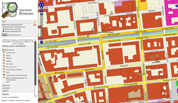
The OpenStreetBrowser (openstreetbrowser.org) is an application to 'browse' through the information in the displayed part of the map. The aim of the project is to provide a highly dynamic map that makes every mapped feature easily available to the user.
Features
- Browse map content in certain categories.
- Wikipedia integration and images (from image, wikipedia, wikimedia_commons, wikidata tags)
- It uses the Overpass API to access the map data and therefore (almost) up-to-date.
- Export selected object or visible map features in various formats (GeoJSON, OSM formats).
- You can create categories yourself, check this howto.
- OpenStreetBrowser is already available in several languages. Follow this how-to to improve translations or create a new one!
History
OpenStreetBrowser started at the end of 2008. Since then it had its ups and downs - in 2016 it was no longer maintainable (it had its own database at that time which used a lot of expensive server resources) and I had to shut it down. In 2017 it was reborn with a new implementation which uses Overpass API. It's been running since then. Read about progress on the OpenStreetBrowser Blog.
How to contribute
- Translate OpenStreetBrowser (Statistics & List of contributors)
- Create your own categories
- Discuss (and implement) ideas for categories in Github issues GitHub
Important modules
- overpass-frontend GitHub: Library for accessing the database and caching the data}}
- overpass-layer GitHub: Module on top of overpass-frontend which shows data on a Leaflet Map}}
- openstreetmap-tag-translations GitHub: Translations of OSM tags
- Leaflet: Popular library for showing maps on websites
See also
External links
- OpenStreetBrowser
- Blog
- Source on GitHub GitHub
- Categories source GitHub
- Translation of UI texts are done via weblate (with the exception of date formatting).

