Potlatch 2

- About
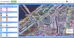
- Potlatch 2 (sometimes referred to as P2) was an OpenStreetMap editor. It required an Adobe Flash plugin in the browser; therefore it did not support all browsers (no plugin was available for some).
- Impact on OpenStreetMap
- Potlatch 2 was completely rewritten from the original Potlatch 1. Both once were the standard editors of OpenStreetMap data. iD took over Potlatch 2's role in 2013.
- Reason for being historic
- Potlatch 2 depends on Adobe Flash to run in a browser. Major browsers removed their support of Flash and blocked the scripts on 12 January 2021 and Potlatch 2 was removed from OSM website. Potlatch 2 was converted into a desktop application (Potlatch 3) running on Windows and MacOS with the support of OSMF.
- Captured time
- January 2021
| Potlatch 2 | ||||||||||||||||||||||||||||||||||||||||||||||||||||||||||||||||||||||||||||||
|---|---|---|---|---|---|---|---|---|---|---|---|---|---|---|---|---|---|---|---|---|---|---|---|---|---|---|---|---|---|---|---|---|---|---|---|---|---|---|---|---|---|---|---|---|---|---|---|---|---|---|---|---|---|---|---|---|---|---|---|---|---|---|---|---|---|---|---|---|---|---|---|---|---|---|---|---|---|---|
| Author: | openstreetmap/potlatch2/graphs/contributors GitHub | |||||||||||||||||||||||||||||||||||||||||||||||||||||||||||||||||||||||||||||
| License: | WTFPL | |||||||||||||||||||||||||||||||||||||||||||||||||||||||||||||||||||||||||||||
| Platform: | Web | |||||||||||||||||||||||||||||||||||||||||||||||||||||||||||||||||||||||||||||
| Status: | Unmaintained | |||||||||||||||||||||||||||||||||||||||||||||||||||||||||||||||||||||||||||||
| Version: | 2.3 (2011-09-30) | |||||||||||||||||||||||||||||||||||||||||||||||||||||||||||||||||||||||||||||
| Language: | English
| |||||||||||||||||||||||||||||||||||||||||||||||||||||||||||||||||||||||||||||
| Website: | https://www.openstreetmap.org/edit?editor=potlatch2 | |||||||||||||||||||||||||||||||||||||||||||||||||||||||||||||||||||||||||||||
| Source code: | openstreetmap/potlatch2 GitHub | |||||||||||||||||||||||||||||||||||||||||||||||||||||||||||||||||||||||||||||
| Programming language: | ActionScript | |||||||||||||||||||||||||||||||||||||||||||||||||||||||||||||||||||||||||||||
|
Web editor coded with Flash technologies |
||||||||||||||||||||||||||||||||||||||||||||||||||||||||||||||||||||||||||||||
| ||||||||||||||||||||||||||||||||||||||||||||||||||||||||||||||||||||||||||||||
Potlatch 2 was completely rewritten from the original Potlatch 1. Its successor is Potlatch 3.
Major features
- User-friendly tagging with customisable presets
- WYSIWYG rendering
- Vector Background Layers
- A more flexible undo/redo system
- OAuth support so you can deploy it on other websites
- ...
Places to use Potlatch 2

Potlatch 2 is on some websites, sometime with customisations:
- It is available inside the "Edit ▼" menu on the www.osm.org homepage (of course you also can select it as your standard editor in your user preferences)
- CycleStreets have deployed it on their website at http://www.cyclestreets.net/edit/
- Test builds are available on https://random.dev.openstreetmap.org/potlatch2/potlatch2.html (using the dev API server, not the main server)
Putting Potlatch 2 on your own website
Potlatch 2 can be hosted on any site, customised to your own requirements, and pointed towards OpenStreetMap. This allows you to deploy customised versions for (say) cycle mappers, individual countries, or whatever you like. See Deploying Potlatch 2 for instructions.
Places where Potlatch 2 is no longer available
Down or discontinuated services
- Potlatch 2 was available on http://www.geowiki.com
- A customised version was available http://open.mapquest.co.uk (MapQuest-open website)
- A customised version was used in the Sustainable London Map project
- Skimap.org was using a customized version for editing ski resorts
- (fa)(Persian) A customised version for tracks, riding is used on GeoMapServer
Services no longer using it
- (de) A customised version for tracks, trails, hiking and riding is used on Hiking- and Ridingmap.
- The USGS was using a customized version the OpenStreetMap Collaborative Prototype.
How to use Potlatch 2
Basic editing
- see the built-in Help system of Potlatch 2
- read more at Potlatch 2/Primer
- Shortcuts (for keyboard and mouse)
- If you want to see the GPS traces of uploaded GPX files, click on the button GPS Data
- watch a video demonstrating how to add points of interest (POIs) in Potlatch 2.
- watch a video demonstrating how to add roads, paths and areas in Potlatch 2.
Advanced editing
- /relations: how to create relations
- /restrictions: for turn restrictions at crossings
- Using vector background layers
- /merging functionality: data conflation (import-related)
Strengths
P2's distinguishing characteristic is that it's extraordinarily ergonomic for moderately familiar users, without ever having too complex an interface. With a handful of keyboard shortcuts you can zip about the map and perform common editing actions efficiently: for example, you can skip 10 nodes back/forward along a way with one keypress, jump to the other end of the way with another, then assign a set of multiple tags to the way (which you've previously recorded) with another single keypress[1].
Development
As of December 2020, Potlatch 2 is no longer maintained. See Developer documentation for some historic development and feedback information.
