Stillwater, OK GIS import
Overview
Please do not attempt to import any features without first consulting the main contacts below.
The goal of this import is to add building and associated address data from publicly available datasets in Stillwater, OK.
The Github repository for all code is here: https://github.com/mikeshenson/Stillwater_OK_OSM_import as well as issues and project tasks.
Data that will be validated and imported on a neighborhood by neighborhood bases.
Contacts
Main contributors/organizers of this project:
- Mike : User page
Technical help
- Importing. OpenStreetMap account required (Create one here)
Source data
Summary
Data is provided by Stillwater. The datasets:
- Building Polygons:
- Address points:
The Building Polygons dataset will be referred to as "bldgs". The Address Points dataset will be referred to as "addrs".
License
These datasets are in the Public Domain
Process
The general process for importing data is described below.
Data processing
- Import building and address data into JOSM
- Import existing OSM buildings (building=*) into JOSM
- Any new building Polygons which intersect existing buildings will, for now, be ignored
- Tags will be created for each building as below
Address Tag Mappings
Remove all tags except "STNAME" and STTYPE to help assign correct addr:street tag.
| tag | source |
| addr:housenumber | STNO |
| addr:street | (expanded)STDIR + STNAME + (expanded)STTYPE (or use addr:full to correctly tag addr:street) |
| addr:unit | STAPT |
| addr:postcode | NEAR_FID |
| addr:city | Stillwater |
| addr:state | OK |
| addr:country | US |
| addr:full | STFULLNAME |
Building Tag Mappings
Remove all tags.
| tag | source |
| building | yes (follow table below) |
| source value | final value |
| Residential Single Family | house |
| Garage | garage |
| RES, Res | residential |
| Duplex, Apartment Complex, Multiplex, Residential Condominiums | apartments |
| Dormitories | dormitory |
| Everything else (the vast majority) | yes |
The bldgs dataset contains a column representing the use of the building "USAGE". The corresponding building= tag will be set as follows (based on http://wiki.openstreetmap.org/wiki/Key:building):
Addresses
Addresses points shall be merged with a building polygon when only one address point is inside or clearly attached to a building polygon. If there are multiple address points inside a building polygon, address points will remain as points.
Import Plan
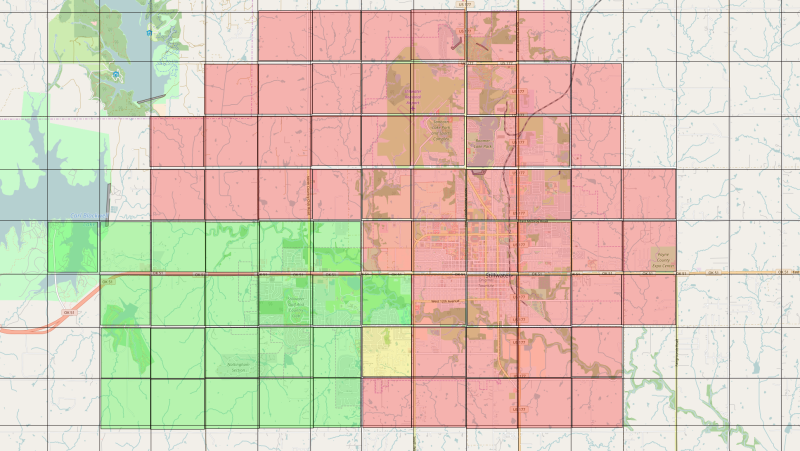
All phases will be preformed on only one mile section at a time before moving onto the next mile section.
Phase 0: Accounts
- User "Stillwater_OK_GIS_Import" is owned by user mhenson
- Contributors/importers will create separate accounts followed by their normal usernames + "_Stillwater_OK_GIS_Import" for import purposes.
Phase 1: The easy stuff
- This phase will only deal with buildings that do not overlap with other features in OSM and have one (or no) address, or simple one building on one Accessors id with multiple addresses
- Contributors will download a section of buildings, and a section of address nodes and validate it in JOSM, verify them with local knowledge & against the most recent imagery available; likely NAIP imagery with Bing as a fall back.
- In JOSM assign correct address tags to the address points.
- In JOSM merge building polygons and address points if they clearly should be merged.
- At this time also verify that the street address matches the street name.
- Run the JOSM validation.
- After validation, the change set for that section will be uploaded by the contributor with a commit message that indicates it is part of this project.
- Uploads shall be small in size max 300 polygons at a time.
Phase 2: Reconciliation with existing buildings/addresses
This phase will involve conflating data to be added to buildings that already exist in OSM and dealing with any complex addressing issues.
Change Sets
Change Sets shall include text "https://wiki.openstreetmap.org/wiki/Stillwater,_OK_GIS_import"
Maintenance Plan
Contributors to this project are (and should be) Stillwater-area community members with an interest in keeping the data up to date.
Progress
OSM Link
Colored Map
- RED = NOT Started
- YELLOW = In Progress
- GREEN = Finished through Phase 2
- GRAY = Not included in import

