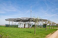
Tag:beacon:type=DVOR/DME
Jump to navigation
Jump to search
| Description |
|---|
| DVOR/DME System |
| Group: aeroways |
| Used on these elements |
| Requires |
| Status: de facto |
| Tools for this tag |
|
A VOR/DME is a combination of VOR and DME.
A DVOR (see DVOR) is often also combined with a radio navigation system for distance measurement - the DME (see DME). DME (Distance Measuring Equipment) displays the distance to the DME transponder in nautical miles (NM). For the DME display in the aircraft, there is a second device whose frequency is coupled with the DVOR receiver so that only the DVOR frequency needs to be set. If the set DVOR does not have a DME, the DME device in the aircraft remains without a display.
How to map
Set a node ![]() where the transmitter is and add
where the transmitter is and add
Useful combination tags
- beacon:code=*
- beacon:frequency=*
- beacon:channel=*
- operator=*
- ele=*
Symbol
Symbol for VOR/DME or DVOR/DME

