Tag:geological=moraine
 |
| Description |
|---|
| Any accumulation of unconsolidated rock debris previously carried by a glacier |
| Group: natural |
| Used on these elements |
| Status: in use |
| Tools for this tag |
|
geological=moraine is used to map accumulations of unconsolidated rock debris previously carried by a glacier - commonly called a ![]() moraine. The tag is predominantly used for mapping young, not or only sparsely vegetated moraines formed by current or recent glaciers and not commonly to map older ice age moraines.
moraine. The tag is predominantly used for mapping young, not or only sparsely vegetated moraines formed by current or recent glaciers and not commonly to map older ice age moraines.
How to map
You can either draw a way along the ridge of a moraine and tag it geological=moraine or draw a closed way around the extent of the moraine (or use Relation:multipolygon for more complex shapes) with the same tag.
The tag is used both for off-glacier as well as on-glacier moraines. For undisturbed off-glacier lateral or terminal moraines the tag is frequently combined with natural=scree. For on-glacier medial moraines this should not be used because of the ambiguity of natural=scree over natural=glacier. Instead the tag surface=scree has been used in some cases, for example in the ADD import. See also glacier:part=moraine.
Examples
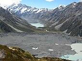
Terminal moraine, Muller glacier, New Zealand

Terminal moraines, Victoria glacier (bottom) and Lefroy glacier (middle), Alberta, Canada

Lateral and medial moraines, Nuussuaq Peninsula, Greenland

Lateral moraine, Lower Theodul glacier, Zermatt, Switzerland

Moraine on the Miage glacier, Italy

The glacier is gone, only the moraine stays, in a valley of the Salcantay Mount, Peru


.jpg)