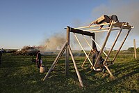
Tag:leisure=village_swing
Jump to navigation
Jump to search
| Description |
|---|
| A traditional large swing designed for multiple adults |
| Group: leisure |
| Used on these elements |
| Useful combination |
| Status: in use |
| Tools for this tag |
|
A village swing (Estonian: külakiik, Finnish: kyläkeinu) is a large swing that is designed to be ridden by multiple adults. They are typically made out of wood and are common on village recreational grounds in Estonia and Finland.
How to Map
Place as a node on the center of the structure.
If located on recreational grounds or park grounds, tag the surrounding area with landuse=recreation_ground or leisure=park.
In Estonia village swing is typically located at külaplats (Village square) and then tag the area as landuse=village_green and always add name for the swing (if village name is Nedsaja, then name should be "Nedsaja külakiik").
To stress that village swing should not be used by small children use baby=no.
Tags to use in combination
- access=* - Use "yes" when on public grounds, "customers" when ticket or admission is required, "private" when specific permission is required.
- operator=*
Similar tags
- playground=swing - More common tag for swings, most commonly usually for swings designed for children
