Tag:leisure=picnic_table
Spring til navigation
Spring til søgning
 |
| Description |
|---|
| A table with benches for food and rest |
| Rendering in OSM Carto |
| Group: leisure |
| Used on these elements |
| Useful combination |
|
| See also |
| Status: de facto |
| Tools for this tag |
|
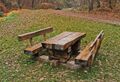
A picnic table is a table with benches, ideal for food and rest.
|
Use leisure=picnic_table if it is a picnic table and only a picnic table. Use tourism=picnic_site if it is a public place and includes several elements, or leisure=outdoor_seating for an outdoor area where customers can eat food and drink from neighbouring cafes / restaurants / pubs. |
How to map?
Place a node ![]() and tag it with leisure=picnic_table.
and tag it with leisure=picnic_table.
Note this tag is most effective for mapping relatively isolated features, e.g. scattered tables in a larger site picnic site. Where there are several tables in a small area, especially if not fixed in position, consider using simply tourism=picnic_site, with leisure=picnic_table reserved for isolated sites.
Additional tags
- covered=* - A property to denote if an object is covered by something
- material=* - Describes the main material of a physical feature
- bench=* - Used to indicate whether the feature has any benches or not. Default assumption is that picnic tables do have seats!
- lit=* - Indicates whether a feature is lit. Default assumption is that picnic sites are rural and so are not lit.
- backrest=* - Whether the benches in picnic table have a backrest to lean against
- colour=* - The colour associated with the object
- access=* - For describing the legal accessibility of a feature. The default assumption is that picnic tables are publicly accessible; leisure=outdoor_seating is more appropriate if access=customers, and private picnic facilities should not really be mapped.
- seasonal=* - Indication when table is there with rough seasonal indication (value domains summer,winter,...). The default assumption is that picnic tables are permanent features with 24/7 access.
- availability=opening_hours - Indication when table is there with value domain of Key:opening_hours, e.g. "availability=Mar-Nov".
- smoking=* - For marking applicable smoking rules. However, if a law mandates a given smoking rule, that need not be mapped
- direction=* - Specifies the direction of a feature
Examples


(286059283
 286059283)

(12095594570
 12095594570)

(12095636350
12095636350)

.jpg)


Rendering
- OSM Carto - A general-purpose OpenStreetMap mapnik style, in CartoCSS
- OSM2World - Converter that creates three-dimensional models of the world from OpenStreetMap data
See also
- picnic_table=yes - Availability of a picnic table at another feature.
- tourism=picnic_site - A locality that is suitable for outdoors eating, with facilities to aid a picnic such as tables and benches
- leisure=outdoor_seating - An outdoor area where customers can eat food and drink from neighbouring cafes / restaurants / pubs.
- amenity=shelter + shelter_type=picnic_shelter - A structure on picnic sites to protect from rain
- amenity=table - A public table
- amenity=bench - A place for people to sit; allows room for several people
- MapContrib theme for benches & picnic tables - Simple online editor to add or edit picnic tables.