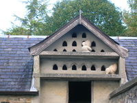
Tag:man_made=dovecote
Jump to navigation
Jump to search
| Description |
|---|
| A place where doves are farmed or stored. |
| Group: man made |
| Used on these elements |
| Useful combination |
|
| Status: in use |
| Tools for this tag |
|
A ![]() dovecote (also dove cote or columbarium) is a building or part of a building where doves are farmed, live or stored.
dovecote (also dove cote or columbarium) is a building or part of a building where doves are farmed, live or stored.
They used to be very common on monastery grounds and country estates.
- Dutch: Duiventoren, Duiventil
- Farsi: کبوترخانه
- French: Colombier, pigeonnier
- German: Taubenhaus, Taubenschlag
- Italian: colombara, torre colombaia
- Spanish: Palomar
- Portugese: Pombal
- Polish: Gołębnik
- Russian: Голубятня
- Swedish: duvslag, duvhus
- Scots: Doocot
- nds-nl: Deuventille
- br: Kouldri
- ca: Colomar
- cs: Holubník
- et: Tuvimaja
- el: Περιστεριώνας
- eo: Kolomba staleto
- eu: Usategi
- gl: Pombal
- he: שובך
Rendering
- iD-editor:


