Talk:WikiProject Piste Maps/Les Trois Vallées
relation site=piste
I used the landuse=winter_sports polygon around 'Les Trois Vallées' to build a site=piste relation in JOSM containing all pistes and aerialways of the resort.
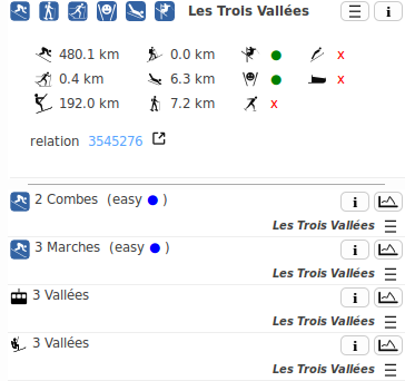
This allows Opensnowmap.org to show stats like that:
(... followed by the ~1200 members of the relation. The length stats ignore the pistes tagged as area=yes).
I'm curious here: what do you think about those relations. Are they maintainable ? Would it make sense to build smaller ones for Courchevel, Val Thorens, etc ... ?
Honestly this was not easy to create at first, as there was so many members to download in JOSM.
--Yvecai (talk) 13:45, 8 March 2014 (UTC)
- As for maintainability, see also my comment on site=piste. In short – I think a relation is difficult to maintain, which is why I think that the concept of a "ski resort" is better represented in other ways than a relation.
- As for other part of the question – "should we tag 3 Vallées as one resort or as sub-resorts" – that is indeed a good question. I can think of two possible (and possibly conflicting) ways to define a ski resort:
- a group of interconnected lifts and pistes
- the area in which a particular ski pass is valid.
- The first definition is an easy one in the case of 3 Vallées: being completely interconnected, it is one resort by that definition. That simple. There may be other cases, though, where this is less clear.
- The second definition is trickier: I can get a ski pass for the entire 3 Vallées complex, or I can get a pass for one of the four sub-resorts Val Thorens/Orelle, Les Menuires/Saint Martin, Méribel and Courchevel/La Tania. Going by ski pass validity, we would either end up with one or four resorts, accordingly.
- If we decide to split the resort by ski pass validity, lifts are easy to assign to their resort. With pistes, this is somewhat tougher – one example that comes to mind is Crêtes between Saint Martin and Méribel. A Saint Martin pass holder may go from S. Martin 2 down Jérusalem and back to the bottom of S. Martin 2 while a Méribel pass holder may go from the top of Tougnète 2 to the bottom of Cherferie – and both would use the same stretch of piste, so which resort does it belong to?
- I don't see how to resolve this one. Also, I think it was me who mapped the polygon around Les 3 Vallées back then – and using one polygon for the whole area was a no-brainer. If we really want to tag things based on ski pass validity, I think it is better to put a tag (e.g. network=* on the lifts. --Stanton (talk) 23:11, 1 April 2014 (UTC)
Hmmm, there is more to this I think. My first use of such a relation was to be able to search for 'Le Risoux', a cross-country domain. Basically it's a forest with nothing else than ski-pistes in winter. Too big an area to be tagged as a place=locality either.
There is two operators grooming the pistes there, and it is accessible from three distinct villages around the hill. It wouldn't be described well by something else than the pistes composing it, or better, a kind of place:ski=locality
How to describe what people usually call Meribel, when they say: 'I'm going at Meribel skiing this week-end' ? This is not the village, neither the small characters on the ski pass, but more a particular set of pistes. --Yvecai (talk) 18:24, 3 April 2014 (UTC)
