uMap/Guide/Edit map properties

The properties of a map define the administrative properties, interactive behavior, appearance and defaults for layers and objects.
These properties can be set/modified by Edit map properties.
Recipe:
- Enter edit mode by ![]()
- Select on the right side Edit Map Settings ![]()
A short description of these properties is shown below. The numbers in the picture refer to the chapters in this article.
Name and description (1)
Enter name and description in the appropiate fields.
The description may contain text formatting
User interface options (2)
- Determine the control elements (buttons) that will be show for map usage. (Zoom, ...
- Determine of a mini map and/or a scale indicator will be shown.
- Determine if a navigation icon is shown in the footer of a popup:
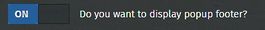 shows
shows  in the popup.
- Determine if a line with map information is shown at the bottom of the map.
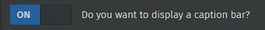 shows
shows  below the map.
Default shape properties (3)
Defaults for properties like color are defined here. These properties are not valid for all objects. For explanation see:
Customize the icon of a marker,
Customize the display of a line,
Customize the display of a polygon
Default properties (4)
Defaults for properties Simplify and dash array are defined here.
- Default zoom level: Setup slideshow
- Advanced Transition: Setup slideshow
- Sort key: Setup slideshow
- Label key: Configure shape interaction

Default interaction options (5)
Defaults for object label and object popup. See Configure shape interaction (labels…) for details.
Custom background (6)

Limit bounds (7)
This option limits the visible area of the map. Further zoom out is impossible.
Deze optie begrenst het gebied dat te zien is van de kaart. Verder uitzoomen kan niet.
The area can be set manually by entering the coordinates (decimal number like 52.143602).
Button Use current bounds may be more comfortable.
Button Empty clears all fields with effect that all zoom levels are possible.
See also function Save this center and zoom. Icon ![]()
Slide show (8)
Credits (9)
Set credits and license. Details in Choose a usage licence for my uMap

Advanced actions (10)
Actions:
- Delete the map !!
- Clone the map
- Empty. Remove all content
- Download. Same effect as
 . Details here.