Geldautomaten taggen - Eine Materialsammlung
How-To on address mapping
Address Scheme
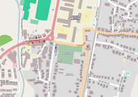
OSM map with buildings and house numbers
In this tutorial I want to explain with the help of some pictures how I map addresses. I selected the Commune Walferdange to map nearly all addresses and points of interest. Because you need some time to map all housenumbers by survey you should select an area where you can spend some time...
I try to stick to the Karlsruhe Schema. I decided to map the house numbers with references to the street name, not to use relations. Furthermore I decided to map nearly all buildings. That sounds to be a huge amount of effort - but it can be done quite fast with the help of the Bing (R) satellite maps. And the maps look so nice with all the houses ;-) For navigation purposes it's not necessary to map them but during the survey it's much easier to map the house numbers if you have all houses on your sheet of paper ...
Tools
Some words about the tools I use:
My favourite editor for OSM is JOSM - it is a powerful tool and you have a lot of nice features to edit a bigger amount of data (you get the last tag as a proposal, so you can save a lot of time). The Bing satellite maps can be integrated by one mouse click.
The second best tool for editing is potlatch (I use version 2) - and it has a big advantage: you can use it in the browser. It has only few features, but for painting buildings it has two very useful commands: to make your rectangle really rectangular (very important!!) and <r> copies all tags from the last marked object. With the help of these two command you paint houses like this (lets assume you've finished the first building in a street with the important tags as a template):
- draw the rectangle (or some more complicated if necessary)
- catch the first point with the line, so that the polygon is closed
- hit
and <r> - that's it!
For mapping POIs I use my GPS device and my mobile. After the tour I use the freeware tool GeoSetter to georeference the photos made with my mobile. This is a very useful and simple technique.
I did not use the terracer plugin for JOSM (described in the WiKi) cause in my commune there are not so many terraced houses.
Other resources
Look also into the detailed decription of the address mapping technique in OSM:
Step by step description
In the table below I describe the steps to paint buildings in OSM with the help of Bing satellite maps. I describe it using Potlatch (the editor you can use within the browser) and JOSM (the editor you have to install in advance on your computer).
Paint the buildings
| Step |
Details |
Picture
|
| Using Potlatch 2
|
| Start OSM |
- start www.openstreetmap.org and select the right detail
- Click on Edit to start Potlatch 2
|
|
| Obtain nearest street name |
- Click on the nearest street (to which the building obviously belongs to)
- copy the street name (name tag) into the clipboard
- if the street name is missing: go out and obtain it!
|
|
| Paint the house |
- Click on one edge according to the satellite pic
- Click on the other edges
- Try to catch the first point again to get a closed polygon
- Hit
to rectangulate the building (if appropriate)
|
|
| Add the tags |
- Click on left bottom edge on "Advanced" to see all tags
- add the building tag building=yes
- add the appropriate addr: tags
|
|
| Paint the other houses |
- Paint the next house the same manner
- Hit <r> to copy all tags from the former select polygon to this one
|
|
| Using JOSM
|
| Start JOSM |
Start JOSM, download the appropriate area, and switch the Bing Satellite pics on (menu Background - Bing Sat)
|
|
| Obtain nearest street name |
- Click on the nearest street (to which the building obviously belongs to)
- copy the street name (name tag) into the clipboard
- if the street name is missing: go out and obtain it!
|
|
| Obtain post code from P&T |
- Open the web site of P&T for searching post codes
- fill in the street name from the clip board
- memorize the post code
- memorize the city name (we use exactly the city name of P&T, but with small caps except the first letter)
|
|
| Create a building template for this street |
- paint the house looking at the satellite map as good as you can as a closed way
- Use keystroke
to rectangulate all corners (if so in reality)
|
|
| Add the tags common to all buildings in this street |
- add the building tag building=yes
- add the appropriate addr: tags
- the tag addr:housenumber=* we will obtain outside, leave it unset for now
|
|
| Use the template for more buildings |
- Select the last painted building (by clicking on the way)
- Move the cursor to the middle of the next building according to the satellite pictures
- Hit CTRL-D, the marked building will be copied with all its tags to the new place
- adjust the corners of the new building, use
for rectangulation if necessary
- repeat this for all houses in the street
|
|
| Special cases ...
|
...if a building belongs to two streets:
- construct two buildings nearby
- tag the street, post code and house number different for both buildings
...if you find more than one street name:
- use the official name (addr:street=*) for address mapping
- if there is a luxembourgish name, tag the street (not the addresses) with name:lb=*
(Remark: The ISO country code for Luxembourg is LU, but the ISO language code for Luxembourgish is lb!)
|
|
| Look at the results |
- Now you have mostly all buildings
- The map looks already nice
- You'll miss the house numbers ;-)
|
|
Go out and obtain the house numbers
| Step |
Details |
Picture
|
| Take the map you've created |
- Print out your map with all the nice buildings
- As Alternative you can use the Walking Papers, it will help you in mapping the
house numbers in JOSM
|
|
| Walk and obtain the house numbers |
- Walk through the streets on your sheet
- Look carefully for the housenumbers
- mostly you'll find them on the house wall, sometimes on the mail box, sometimes on the waste container ... and sometimes you don't find them at all
- You can take pictures and geo reference them later (see below)
|
|
| Add buildings not yet in Bing Maps |
- Sometimes you'll see new buildings not yet in Bing satellite maps
- Draw them roughly on your sheet and obtain the street name and house number
- Add the building in JOSM and add the right tags
|
|
| Building under construction |
- If a building is just being built, add the tag construction=yes
- Mapnik and Osmarender don't render them differently, but may be other applications will do
- OSM navigation apps will find the new house ... this way OSM is faster than anything else :-)
- Don't forget to delete the tag, when the house has been built completely
|
|
Tag the buildings with the obtained house numbers depending on the situation
| Situation |
Details |
Picture
|
| The building has one house number |
- if the building has exactly one house number, tag the building directly with the addr:housenumber=*
- you don't need an address node
|
|
| The building has two house numbers |
- if the building has exactly two house numbers, you'll need two create two address nodes within the building
- position the nodes at the ends of the building, more to the street side
- The numbers can be either consecutive, or they can have a difference of two (if you have only odd or even numbers)
- Tag the nodes with addr:street=* and addr:housenumber=*
- The street name must exactly match the name=* tag of the street.
|
|
| The building has more then two house numbers |
- If the building has more than two house numbers, you don't need to draw them all
- You can define instead an interpolation rule between the two nodes:
- Draw a line between the two nodes and tag it with addr:interpolation=*
- Most used values are:
- full: the numbers are consecutive
- odd: only odd numbers
- even: only even numbers
|
|
| You find house numbers with letters |
- If the house number is the only one in the building, just add the letter to the number
(I prefer small caps, but that is not important)
- If the number with the letter is within a range, you should interrupt the range and draw a node for this special number (see pic)
- If there are consecutive letters you can use addr:interpolation=alphabetic
|
|
| Be happy :-) |
- The house numbers are rendered in Mapnik and in Osmarender
- So you can have a closer look on your work with both map styles
|
|
Check the mapping
| Step |
Details |
Picture
|
| Use OSM inspector of GeoFabrik |
- start OSM Inspector by GeoFabrik
- Select your mapping area and zoom in that you can see all house numbers
|
|


