Zh-hans:Featured images/Jan-Mar 2018
Jump to navigation
Jump to search


这是特色图片,展现开放街图画地图范例,以及最能代表开放街图的专案。
如果你知道其他有类似品质的图片,你可以在特色图片提名处(en)提名。
| ← 从2017年1月到3月 | ← 从2017年10月到12月 | 从2018年4月到6月 → | 从2019年1月到3月 → |
特色图片库、从2018年1月到3月
2018年、第1周
2018年、第2周
2018年、第3周

2018年、第4周

2018年、第5周

2018年、第6周
2018年、第7周
2018年、第8周
2018年、第9周
2018年、第10周

2018年、第11周
2018年、第12周
2018年、第13周
细节和字幕
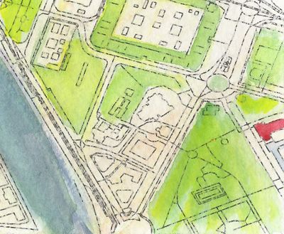
第1周(从2018年1月1日星期一到2018年1月7日星期日) [Edit]

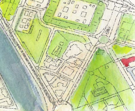
- English : Detail from a watercolour map of Seville, created by Andrew McGuire as a Christmas present for his wife. Hand-painted upon an OpenStreetMap base-map via Mapzen.
- 中文(简体) : Andrew McGuire 制作的塞维利亚详细水墨画地图,是给他太太的耶诞节礼物,依据Mapzen 基于开放街图资料手绘制作。
第2周(从2018年1月8日星期一到2018年1月14日星期日) [Edit]

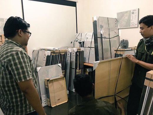
- English : As part of the InAWARE project by HOT in Indonesia, 500 framed OpenStreetMap maps were delivered to village offices around Jakarta, to help officials identify infrastructure in their area. Previously many such offices used rough hand-drawn maps.
- 中文(简体) : 属于HOT 小组InAWARE 计画的一部分,分送500 幅表框的开放街图地图到[ [Jakarta
第3周(从2018年1月15日星期一到2018年1月21日星期日) [Edit]

- English : Car parks take up a lot of space within our cities. What The Street visualises this and other uses of city space for cars, trains, and cycles using OpenStreetMap data.
- 中文(简体) : 停车空间占据不小的都市空间。What The Street 运用开放街图资料,视觉化都市停车空间,并且还显示汽车、火车和单车空间。
第4周(从2018年1月22日星期一到2018年1月28日星期日) [Edit]
- English : Christian Quest's latest creation is a 3D printed OpenStreetMap logo shaped cookie-cutter!
- 中文(简体) : Christian Quest 最新的创造是 3D 列印的开放街图 logo 形状的蛋糕形状切割器!
第5周(从2018年1月29日星期一到2018年2月4日星期日) [Edit]

- English : No image was featured this week.
第6周(从2018年2月5日星期一到2018年2月11日星期日) [Edit]

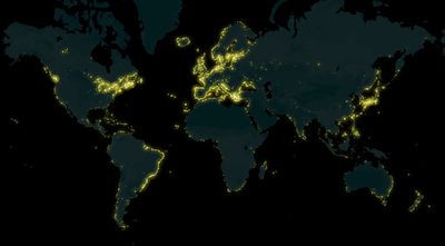
- English : A map of lighthouses all over the world mapped on OpenStreetMap, made by Arun Ganesh (planemad). See also the interactive map on MapBox.
- 中文(简体) : Arun Ganesh (planemad) 利用开放街图资料绘制的全球灯塔地图。另外请见 Mapbox 上的互动地图
第7周(从2018年2月12日星期一到2018年2月18日星期日) [Edit]

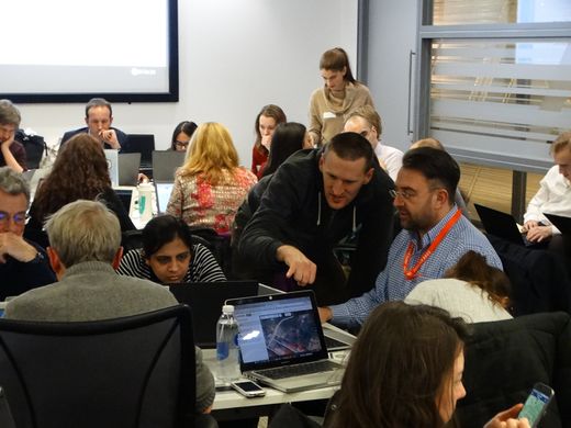
- English : Sharing OpenStreetMap editing techniques at the regular Missing Maps Project event in London.
- 中文(简体) : 在伦敦寻常的 Missing Maps 计画的聚会上面,大家彼此分享开放街图的编辑技术。
第8周(从2018年2月19日星期一到2018年2月25日星期日) [Edit]

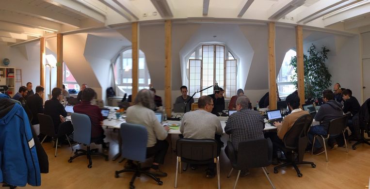
- English : Working on OpenStreetMap tech at the Karlsruhe Hack Weekend.
- 中文(简体) : Karlsruhe Hack Weekend 时动手弄开放街图技术。
第9周(从2018年2月26日星期一到2018年3月4日星期日) [Edit]

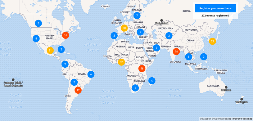
- English : This year Open Data Day will be celebrated on March 3rd and there are already 406 events registered all around the world. Many of them will have activities related to OpenStreetMap.
") Check out the map and participate in an event near you!
Check out the map and participate in an event near you! - 中文(简体) : 今年开放资料日将在 3 月 3 日举行,全球有 406 个注册的活动。许多活动与开放街图有关。 察看地图并且参加离你最近的活动吧!
第10周(从2018年3月5日星期一到2018年3月11日星期日) [Edit]

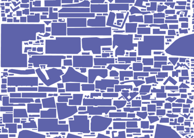
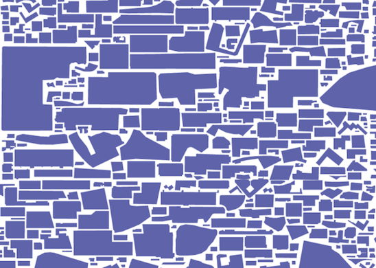
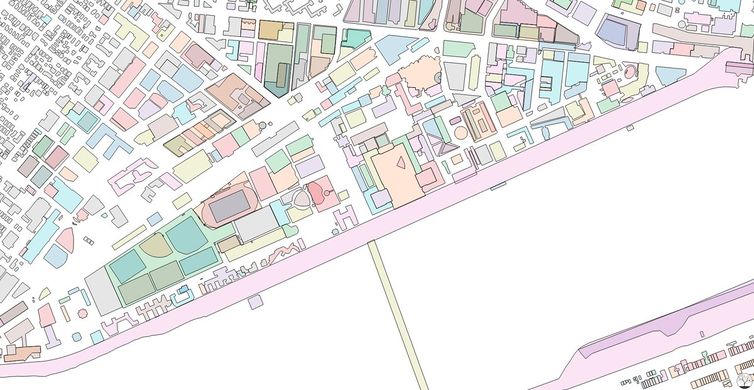
- English : Colorful exploration of OpenStreetMap buildings data on the MIT Campus in Cambridge, Massachusetts, United States. Map produced by Curran Kelleher [1].
- 中文(简体) : 美国麻塞诸塞州剑桥一带开放街图建筑资料彩色式的探险。地图由 Curran Kelleher [2] 制作。
第11周(从2018年3月12日星期一到2018年3月18日星期日) [Edit]

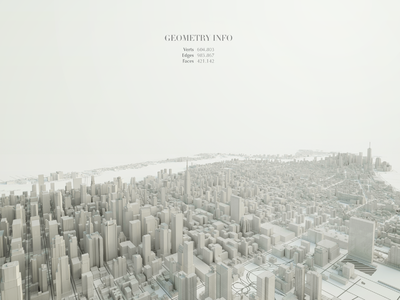
- English : Beautiful 3D visualization of Manhattan's OpenStreetMap data. Made by Matteo Prati using the open source software Blender. Check out other images in his website.
- 中文(简体) : 曼哈顿开放街图资料的漂亮 3D 视觉化,由 Matteo Prati 用开源软体 Blender 制作。 到他网站看更多图片吧。
第12周(从2018年3月19日星期一到2018年3月25日星期日) [Edit]

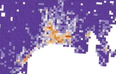
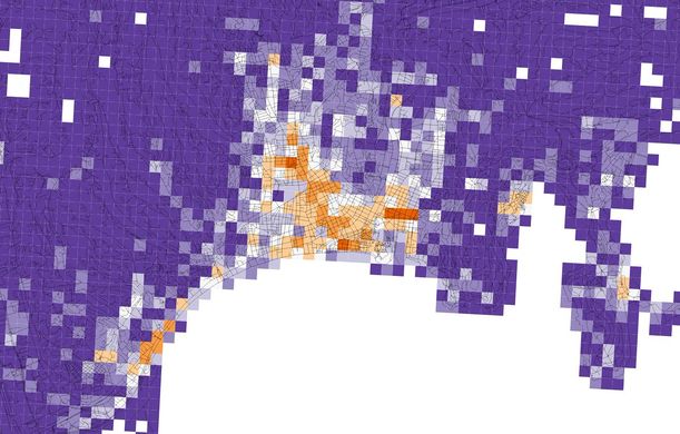
- English : Diversity of OpenStreetMap retail and services in Nice, Alpes-Maritimes, Provence-Alpes-Côte d'Azur, France. Orange tiles indicate a high diversity, while purple tiles indicate a low diversity. Image produced by Alessandro Venerandi.
- 中文(简体) : 法国普罗旺斯-阿尔卑斯-蔚蓝海岸大区滨海阿尔卑斯省尼斯开放街图零售和服务的多样性,橘色色块显示高密度,白色色块显示低密度,图片由Alessandro Venerandi 制作。
第13周(从2018年3月26日星期一到2018年4月1日星期日) [Edit]

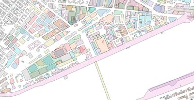
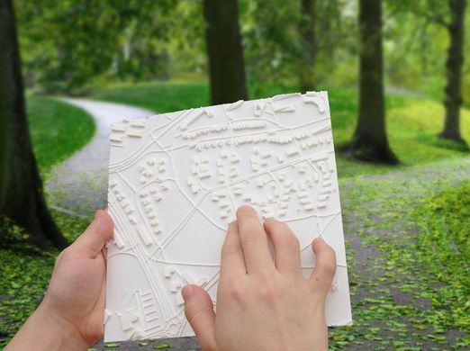
- English : Touch Mapper (touch-mapper.org) lets you create a 3D printed maps based on OpenStreetMap data. Tactile maps like this can be used for navigation by the blind.
- 中文(简体) : Touch Mapper (touch-mapper.org) 让你用开放街图资料产生 3D 列印的地图,这样的立体图能用在视觉障碍导航上面。