File:1936 Korea Panoramic Map of Railway - Geographicus.jpg
Original file (3,183 × 837 pixels, file size: 778 KB, MIME type: image/jpeg)
| Railroad Map of Korea. | ||||||
|---|---|---|---|---|---|---|
| Artist | ||||||
| Title |
Railroad Map of Korea. |
|||||
| Description |
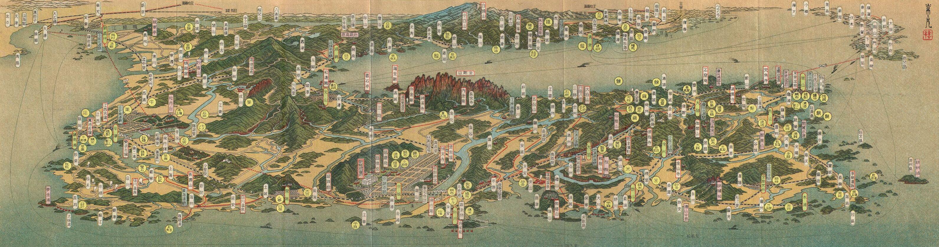
English: An extremely attractive 1936 or Showa 11 panoramic view map of Korea. This uncommon type of map evolved out of traditional Japanese view-style cartography and began to appear in Japan, Taiwan, and Korea in the early 20th century. Generally speaking such maps coincided with the development of railroad lines throughout the once vast Dai Nippon Teikoku or Japanese Empire. It is a distinctive style full of artistic flourish that at the same time performs a practical function. This particular example is both relatively early and exceptionally beautiful. It was printed via a multi-color lithographic process with delicate subdued tones and a easily comprehensible intuitive design. Oriented to the northeast Korea appears in the foreground with major cities and notable geological formations exaggerated in proportion. In the background we can see parts of Japan and Manchuria. In addition to rail lines, roadways and seaways are noted. Folds into itself, accordion style, with an art deco style cover depicting Seoul at the left end. Verso features additional Japanese text, a smaller map, and nine photographs showing off the people and country of Korea. |
|||||
| Date | 1936 or Showa 11 (dated) | |||||
| Dimensions | height: 7 in (17.7 cm); width: 24 in (60.9 cm) | |||||
| Accession number |
Geographicus link: KoreaPanorama-showa11-1936 |
|||||
| Source/Photographer |
|
|||||
| Permission (Reusing this file) |
|
|||||
| Other versions | ||||||
File history
Click on a date/time to view the file as it appeared at that time.
| Date/Time | Thumbnail | Dimensions | User | Comment | |
|---|---|---|---|---|---|
| current | 07:21, 14 October 2023 | 3,183 × 837 (778 KB) | wikimediacommons>Koreller | File:1936 Showa 11 Panoramic Map View of Korea - Geographicus - KoreaPanorama-showa11-1936.jpg cropped 20 % horizontally, 29 % vertically, rotated -0.23° using CropTool with precise mode. |
File usage
The following page uses this file: