File:Aussfeld Markgröningen Karte von 1751-52.jpeg
Jump to navigation
Jump to search

Size of this preview: 609 × 600 pixels. Other resolutions: 244 × 240 pixels | 487 × 480 pixels | 780 × 768 pixels | 1,040 × 1,024 pixels | 2,080 × 2,048 pixels | 4,419 × 4,352 pixels.
Original file (4,419 × 4,352 pixels, file size: 3.11 MB, MIME type: image/jpeg)
This file and its description are from Wikimedia Commons.
| Description |
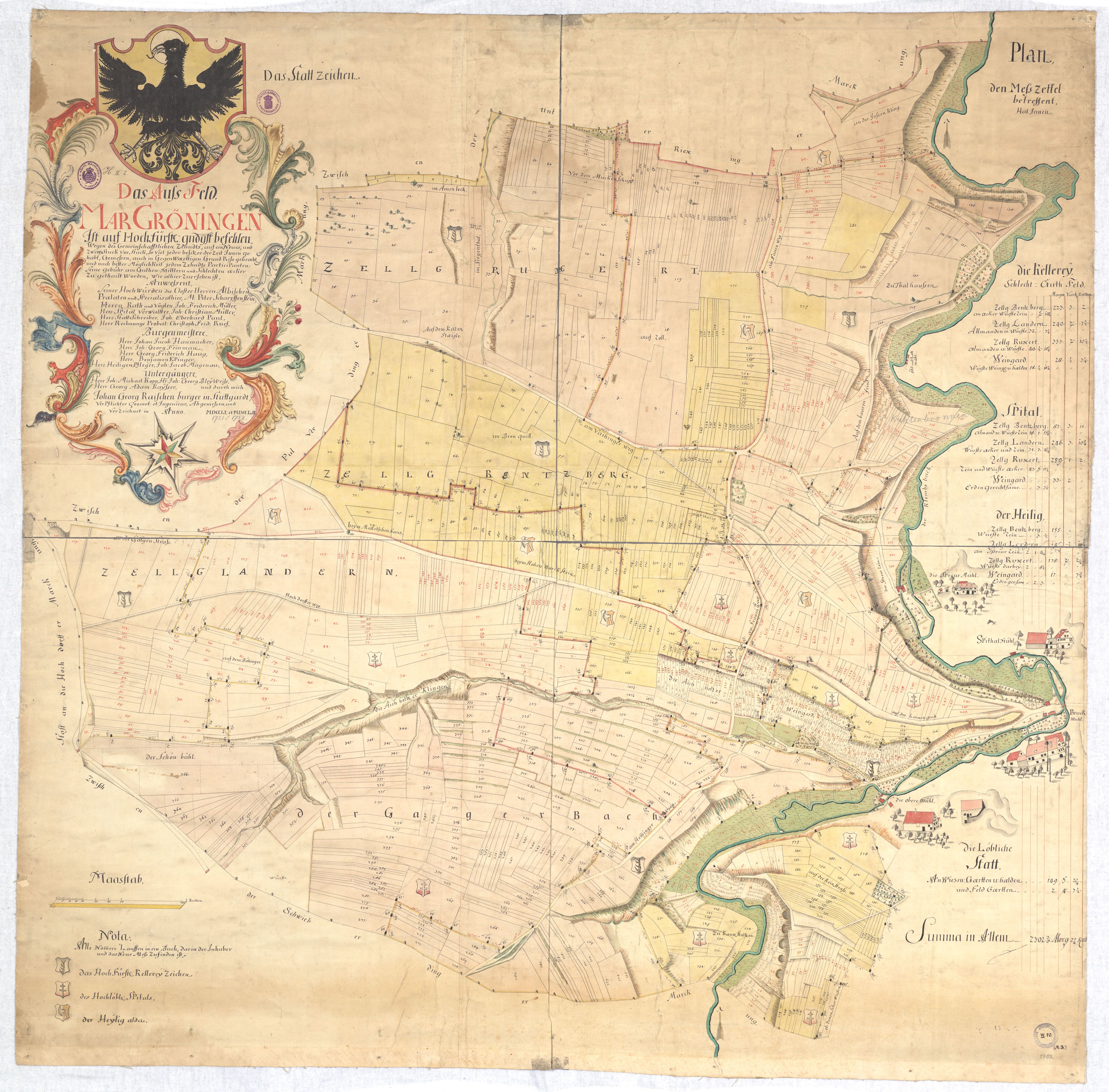
Deutsch: Situation des größtenteils links der Glems gelegenen „Aussfelds“ mit nummerierten Parzellen und Zelgen mit Kennzeichnung der Zehntberechtigten / Angabe der Zehntberechtigten durch deren Wappen (Württemberg, Spital zu Markgröningen, Kirchenheiliger daselbst) / Lauf der Glems mit vier Mühlen (diese auch in bildhafter Wiedergabe) / Erklärung der Wappen, tabellarische Übersicht der Flächengehalte der Zehntbereiche, getrennt nach Zelgen bzw. Weinbaugebiet, mit Anteil wüster bzw. als Rain und Allmende geltender Flächen / Titel in Rokokorahmen, gekrönt von Stadtwappen, enthaltend Namen der an der Begehung des Geländes beteiligten Personen (herzogliche Beamte, Bürgermeister, Heiligenpfleger, Untergänger) |
|||||
| Date | 1751/52 | |||||
| Source | landesarchiv-bw.de (N 1 Nr. 85) | |||||
| Author | Johann Georg Raisch | |||||
| Permission (Reusing this file) |
|
|||||
File history
Click on a date/time to view the file as it appeared at that time.
| Date/Time | Thumbnail | Dimensions | User | Comment | |
|---|---|---|---|---|---|
| current | 12:07, 1 April 2014 | | 4,419 × 4,352 (3.11 MB) | wikimediacommons>Pustekuchen2014 | {{Information |Description ={{de|1=Situation des größtenteils links der Glems gelegenen Komplexes an Äckern und Weinbergen mit nummerierten Parzellen sowie Grenzen zwischen den einzelnen Zehntberechtigten / Angabe der Zehntberechtigten durch dere... |
File usage
There are no pages that use this file.