File:Bad gdop.png
Jump to navigation
Jump to search


Size of this preview: 670 × 600 pixels. Other resolutions: 268 × 240 pixels | 536 × 480 pixels | 858 × 768 pixels.
Original file (858 × 768 pixels, file size: 848 KB, MIME type: image/png)
This file and its description are from Wikimedia Commons.
| Description |
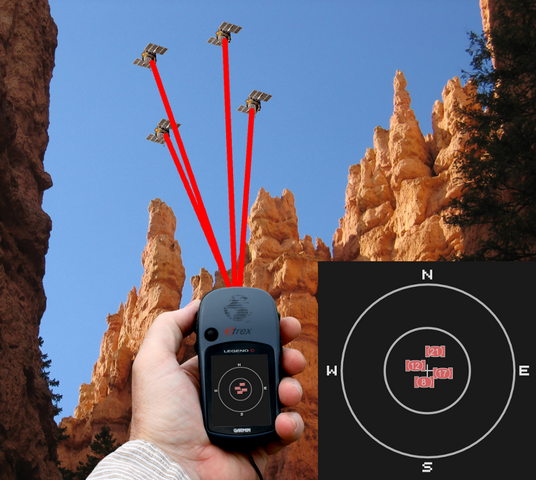
English: GPS satellites with poor geometry for Global Dillution of Precision (GDOP).
Español: Satélites GPS con mala geometría para la GDOP (Global Dilution of Precision: Disolución Global de Precisión). |
| Date | (UTC) |
| Source | |
| Author |
|
| Other versions | File:Bad_gdop.xcf |
This file is licensed under the Creative Commons Attribution-Share Alike 3.0 Unported license.
- You are free:
- to share – to copy, distribute and transmit the work
- to remix – to adapt the work
- Under the following conditions:
- attribution – You must give appropriate credit, provide a link to the license, and indicate if changes were made. You may do so in any reasonable manner, but not in any way that suggests the licensor endorses you or your use.
- share alike – If you remix, transform, or build upon the material, you must distribute your contributions under the same or compatible license as the original.
Original upload log
This image is a derivative work of the following images:
- File:Bryce_Canyon_Hoodoos.jpg licensed with Cc-by-sa-2.5, Cc-by-sa-3.0-migrated, GFDL
- File:Garmin_eTrex_Legend_C_in_hand.jpg licensed with Cc-by-2.0
- 2009-10-31T20:52:00Z File Upload Bot (Magnus Manske) 3035x2469 (1728179 Bytes) {{Information |Description=Earthcache De Slufter |Source=[http://www.flickr.com/photos/45581782@N00/2790084895/ Earthcache De Slufter] * Uploaded by [[User:Partyzan_XXI|Partyzan_XXI]] |Date=2008-08-17 14:39 |Author=[http://ww
- File:Navstar-2.jpg licensed with PD-USGov-Military-Air Force
- 2005-03-26T18:06:36Z GDK 400x400 (20897 Bytes) NAVSTAR-2 (GPS-2) satellite Source: http://www.jpl.nasa.gov/images/grace/grace_083002_browse.jpg Status: PD-USGov-Military-Air Force {{PD-USGov-Military-Air Force}} [[Category:Satellites]]
- File:Bad_gdop_screen.svg licensed with Cc-by-sa-3.0, GFDL
- 2010-04-09T22:21:57Z Javiersanp 400x400 (13909 Bytes) {{Information |Description={{en|1=GPS receiver satellite info screen showing a poor satellite geometry for Global Dilution of Precision (GDOP).}} {{es|1=Pantalla de información de satélites de un receptor GPS mostrando una
Uploaded with derivativeFX
File history
Click on a date/time to view the file as it appeared at that time.
| Date/Time | Thumbnail | Dimensions | User | Comment | |
|---|---|---|---|---|---|
| current | 23:22, 9 April 2010 | | 858 × 768 (848 KB) | wikimediacommons>Javiersanp | {{Information |Description={{en|1=GPS satellites with poor geometry for Global Dillution of Precision (GDOP).}} {{es|1=Satélites GPS con mala geometría para la GDOP (Global Dilution of Precision: Disolución Global de Precisión).}} |Source=*[[:File:Bry |