File:Central American Wildfires Continue (MODIS 2024-05-27).jpg

Original file (4,338 × 3,197 pixels, file size: 2.19 MB, MIME type: image/jpeg)
Summary
| Description |
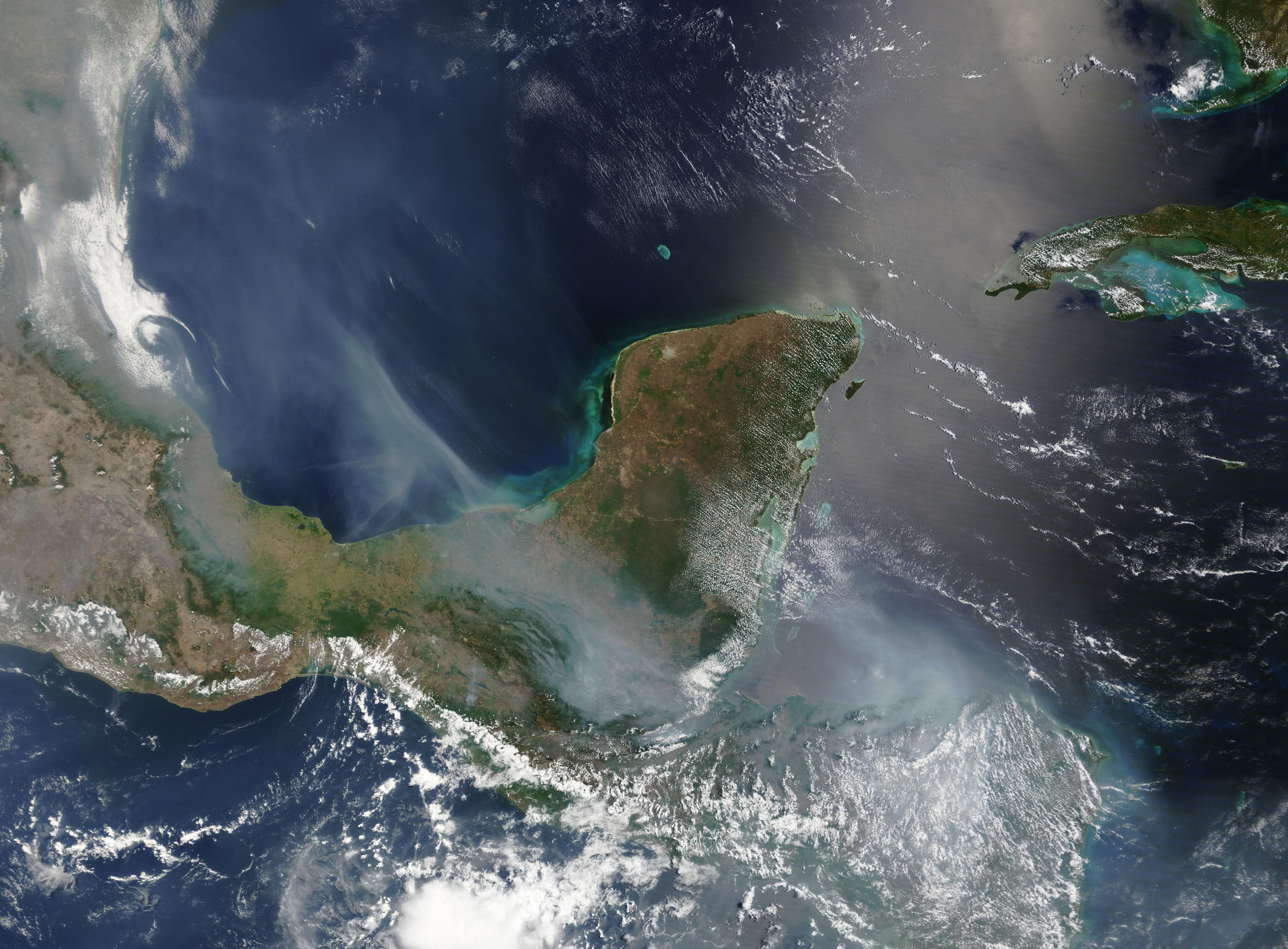
English: High temperatures and low rainfall spurred on a vicious fire season in Central America through May 2024.
On May 24, the Moderate Resolution Imaging Spectroradiometer (MODIS) acquired a true-color image of copious thick smoke over Mexico, Belize, Guatemala, El Salvador, and Honduras. The smoke is thickest over the Caribbean Sea and Honduras, where both the land and the sea were almost completely obscured from view. Smoke also stretched over the Gulf of Mexico and accumulated over coastal Mexico east of the Sierra Madre Oriental. On May 15, more than 200 active fires were reported burning across Mexico and Central America, according to media outlets. Many of these were undoubtedly fires that were deliberately ignited and controlled for agricultural uses. However, there are also many reports of widespread wildfires, some of which are very large. For example, three wildfires outside of Cancun, Mexico, located at the northeastern tip of the Yucatan Peninsula, had burnt more than 1,000 hectares (2,471 acres). On May 26, the Crisis24 newsletter advised that wildfires have severely impacted several locations in Belize, especially in southern and western sections of that country. Officials estimate that approximately a third of the Mountain Pine Ridge Forest Reserve in the Cayo District has burnt. In Toledo District, large tracts of agricultural land have been destroyed. Emergency wildfire operations are ongoing and likely to continue across Belize through at least early June. |
||
| Date | Taken on 24 May 2024 | ||
| Source |
Central American Wildfires Continue (direct link)
|
||
| Author | MODIS Land Rapid Response Team, NASA GSFC |
| This media is a product of the Terra mission Credit and attribution belongs to the mission team, if not already specified in the "author" row |
Licensing
| This file is in the public domain in the United States because it was solely created by NASA. NASA copyright policy states that "NASA material is not protected by copyright unless noted". (See Template:PD-USGov, NASA copyright policy page or JPL Image Use Policy.) | ||
 |
Warnings:
|
File history
Click on a date/time to view the file as it appeared at that time.
| Date/Time | Thumbnail | Dimensions | User | Comment | |
|---|---|---|---|---|---|
| current | 05:05, 27 May 2024 | | 4,338 × 3,197 (2.19 MB) | wikimediacommons>OptimusPrimeBot | #Spacemedia - Upload of http://modis.gsfc.nasa.gov/gallery/images/image05272024_500m.jpg via Commons:Spacemedia |
File usage
The following page uses this file:
.jpg)