File:H - geograph.org.uk - 1110554 (cropped).jpg
Jump to navigation
Jump to search


No higher resolution available.
H_-_geograph.org.uk_-_1110554_(cropped).jpg (381 × 508 pixels, file size: 36 KB, MIME type: image/jpeg)
This file and its description are from Wikimedia Commons.
Summary
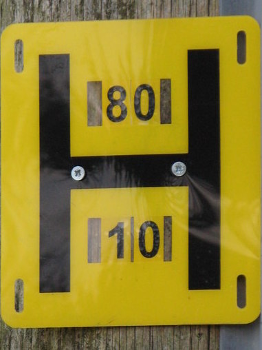
| Description |
English: H ... is for (water) hydrant; for the location, see 1110555. I am indebted to AlastairG for the following information about the numbers in the sign: the upper number (80) gives the diameter of the feed pipe in mm; the lower number (10) gives the distance in metres from the sign to the manhole or metal cover over the pipe. |
| Date | |
| Source |
This file was derived from: H - geograph.org.uk - 1110554.jpg |
| Author | Mike Quinn |
| Other versions | |
| Attribution (required by the license) | Mike Quinn / H / |

| Camera location | | View this and other nearby images on: OpenStreetMap |
|---|
.jpg¶ms=054.898160_N_-002.246300_E_globe:Earth_type:camera_source:geograph-osgb36(NY84305596)_heading:135.00&language=en)
| Object location | | View this and other nearby images on: OpenStreetMap |
|---|
.jpg¶ms=054.897990_N_-002.245900_E_globe:Earth_class:object_type:object_source:geograph-osgb36(NY84325594)_heading:135.00&language=en)
Licensing
This file is licensed under the Creative Commons Attribution-Share Alike 2.0 Generic license.
Attribution: Mike Quinn
- You are free:
- to share – to copy, distribute and transmit the work
- to remix – to adapt the work
- Under the following conditions:
- attribution – You must give appropriate credit, provide a link to the license, and indicate if changes were made. You may do so in any reasonable manner, but not in any way that suggests the licensor endorses you or your use.
- share alike – If you remix, transform, or build upon the material, you must distribute your contributions under the same or compatible license as the original.
File history
Click on a date/time to view the file as it appeared at that time.
| Date/Time | Thumbnail | Dimensions | User | Comment | |
|---|---|---|---|---|---|
| current | 19:51, 19 November 2021 | | 381 × 508 (36 KB) | wikimediacommons>Pigsonthewing | File:H - geograph.org.uk - 1110554.jpg cropped 21 % horizontally, 21 % vertically using CropTool with lossless mode. |
File usage
The following 2 pages use this file:
.jpg)