File:Karte- Flughafen Berlin-Schönefeld SXF.png
Jump to navigation
Jump to search


Size of this preview: 602 × 600 pixels. Other resolutions: 241 × 240 pixels | 482 × 480 pixels | 771 × 768 pixels | 1,028 × 1,024 pixels | 2,272 × 2,264 pixels.
Original file (2,272 × 2,264 pixels, file size: 1,002 KB, MIME type: image/png)
This file and its description are from Wikimedia Commons.
Summary
| Description |
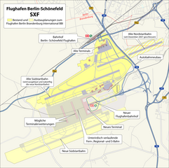
Deutsch: Karte: Flughafen Berlin-Schönefeld SXF mit Darstellung der Ausbauplanungen zum Flughafen Berlin Brandenburg International BBI |
|||||||||
| Date | ||||||||||
| Source |
Self made, using
|
|||||||||
| Creator |
Maximilian Dörrbecker (Chumwa)
|
|||||||||
| Permission (Reusing this file) |
I, the copyright holder of this work, hereby publish it under the following license: This file is licensed under the Creative Commons Attribution-Share Alike 2.5 Generic license.
Sie dürfen das Bild zu den folgenden Bedingungen nutzen:
|
|||||||||
| Geotemporal data | ||||||||||
| Bounding box |
|
|||||||||
| Georeferencing | ||||||||||
| Other versions |
|
|||||||||


|
This architecture image could be re-created using vector graphics as an SVG file. This has several advantages; see Commons:Media for cleanup for more information. If an SVG form of this image is available, please upload it and afterwards replace this template with
{{vector version available|new image name}}.
It is recommended to name the SVG file “Karte- Flughafen Berlin-Schönefeld SXF.svg”—then the template Vector version available (or Vva) does not need the new image name parameter. |
File history
Click on a date/time to view the file as it appeared at that time.
| Date/Time | Thumbnail | Dimensions | User | Comment | |
|---|---|---|---|---|---|
| current | 05:20, 16 June 2008 | | 2,272 × 2,264 (1,002 KB) | wikimediacommons>Chumwa | Anmerkungen von Incontro eingearbeitet (vielen Dank hierfür!) |
File usage
The following 2 pages use this file: