File:OpenStreetMap's River Sherbourne relation, seen in Wikidata using 'osm' user script.png
Jump to navigation
Jump to search


Size of this preview: 600 × 600 pixels. Other resolutions: 240 × 240 pixels | 630 × 630 pixels.
Original file (630 × 630 pixels, file size: 681 KB, MIME type: image/png)
This file and its description are from Wikimedia Commons.
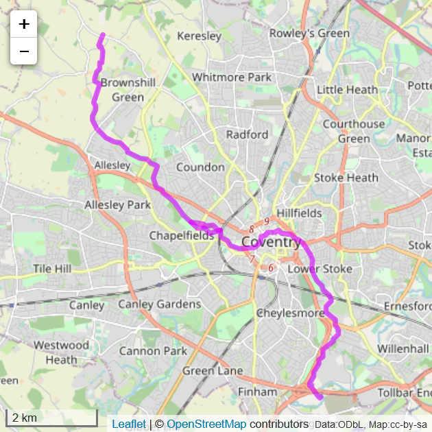
Summary
| Description |
English: OpenStreetMap's River Sherbourne relation, seen in Wikidata using the 'User:Abbe98/osm.js' user script |
| Date | |
| Source | https://www.wikidata.org/wiki/Q7337804 |
| Author | OpenStreetMap contributors |
Licensing
This file is licensed under the Creative Commons Attribution-Share Alike 3.0 Unported license.
- You are free:
- to share – to copy, distribute and transmit the work
- to remix – to adapt the work
- Under the following conditions:
- attribution – You must give appropriate credit, provide a link to the license, and indicate if changes were made. You may do so in any reasonable manner, but not in any way that suggests the licensor endorses you or your use.
- share alike – If you remix, transform, or build upon the material, you must distribute your contributions under the same or compatible license as the original.
File history
Click on a date/time to view the file as it appeared at that time.
| Date/Time | Thumbnail | Dimensions | User | Comment | |
|---|---|---|---|---|---|
| current | 19:00, 16 December 2020 | | 630 × 630 (681 KB) | wikimediacommons>Pigsonthewing | Uploaded a work by OpenStreetMap contributors from https://www.wikidata.org/wiki/Q7337804 with UploadWizard |
File usage
The following page uses this file: