File:Otok Jabuka 2008.jpeg
Jump to navigation
Jump to search


Size of this preview: 800 × 533 pixels. Other resolutions: 320 × 213 pixels | 640 × 427 pixels | 1,024 × 683 pixels | 1,200 × 800 pixels.
Original file (1,200 × 800 pixels, file size: 280 KB, MIME type: image/jpeg)
This file and its description are from Wikimedia Commons.
Summary
| Description |
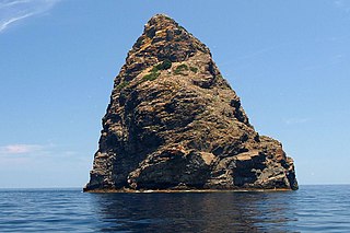
Hrvatski: Zapadna strana otoka Jabuke |
| Date | 25 May 2013 (original upload date) |
| Source | Own work by the original uploader |
| Author | The original uploader was Fbundalo at Croatian Wikipedia. |
Licensing
This file is licensed under the Creative Commons Attribution 2.5 Generic license.
- You are free:
- to share – to copy, distribute and transmit the work
- to remix – to adapt the work
- Under the following conditions:
- attribution – You must give appropriate credit, provide a link to the license, and indicate if changes were made. You may do so in any reasonable manner, but not in any way that suggests the licensor endorses you or your use.
Original upload log
Transferred from hr.wikipedia to Commons by BokicaK using CommonsHelper.
The original description page was here. All following user names refer to hr.wikipedia.
- 2013-05-25 16:51 Fbundalo 2000×1287× (300768 bytes) {{Infoslika |Opis= Zapadna strana otoka Jabuke |Izvor= vlastiti rad |Datum= 21. 06. 2008. |Autor= Filip Bundalo |Objašnjenje= Zapadna strana otoka Jabuke. Uslikano tokom ekspedicije "Jabuka 2008" Udruge pustolova i sportaša iz Velike Gorice }}
File history
Click on a date/time to view the file as it appeared at that time.
| Date/Time | Thumbnail | Dimensions | User | Comment | |
|---|---|---|---|---|---|
| current | 08:31, 2 May 2022 | | 1,200 × 800 (280 KB) | wikimediacommons>Argo Navis | Cropped 40 % horizontally, 38 % vertically, rotated -1° using CropTool with precise mode. |
File usage
The following page uses this file: