File:Sunokobashi Tailings Dam survey 1976.jpg
Jump to navigation
Jump to search


Size of this preview: 451 × 600 pixels. Other resolutions: 180 × 240 pixels | 361 × 480 pixels | 669 × 890 pixels.
Original file (669 × 890 pixels, file size: 121 KB, MIME type: image/jpeg)
This file and its description are from Wikimedia Commons.
Summary
| Description |
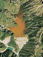
English: Sunokobashi Tailings Dam in Ashio copper mine.
日本語: 足尾銅山の簀子橋堆積場。 |
| Date | |
| Source | Japan Ministry of Land, Infrastructure and Transport. [1] |
| Author | Retouch: Qurren (talk). |
| Other versions |
.jpg)
| Camera location | | View this and other nearby images on: OpenStreetMap |
|---|
Licensing

|
The copyright holder of this file, the Ministry of Land, Infrastructure, Transport and Tourism of Japan, allows anyone to use it for any purpose, provided that the copyright holder is properly attributed. Redistribution, derivative work, commercial use, and all other use is permitted. |
Attribution:
Copyright © National Land Image Information (Color Aerial Photographs), Ministry of Land, Infrastructure, Transport and Tourism
|
 |
This image is copyrighted by the Ministry of Land, Infrastructure, Transport and Tourism of Japan. For terms of use, see the stipulation to use of National Land Information (in Japanese) and message from MLIT (in Japanese and English). When you display this image on an article, include the following phrase in the description: "Made based on National Land Image Information (Color Aerial Photographs), Ministry of Land, Infrastructure, Transport and Tourism".
|
File history
Click on a date/time to view the file as it appeared at that time.
| Date/Time | Thumbnail | Dimensions | User | Comment | |
|---|---|---|---|---|---|
| current | 11:22, 17 December 2009 | | 669 × 890 (121 KB) | wikimediacommons>Qurren | {{Information |Description={{en|1=Sunokobashi Tailings Dam in en:Ashio copper mine.}} {{ja|1=ja:足尾銅山の簀子橋堆積場。}} |Source=Japan Ministry of Land, Infrastructure and Transport. [http://w3land.mlit.go.jp/cgi-bin/WebGIS2/WC_A |
File usage
The following 2 pages use this file: