File:Topographic prominence.png
Jump to navigation
Jump to search


No higher resolution available.
Topographic_prominence.png (533 × 357 pixels, file size: 525 KB, MIME type: image/png)
This file and its description are from Wikimedia Commons.
Summary
| Description |
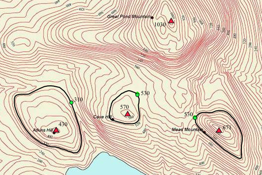
English: Map showing the topographic prominence of three peaks near Great Pond Mountain, Maine |
| Date | |
| Source | Own work |
| Author | Salix alba |
| Camera location | | View this and other nearby images on: OpenStreetMap |
|---|
Derived from File:Cntr-map-1.jpg.
Licensing
I, the copyright holder of this work, hereby publish it under the following license:
This file is licensed under the Creative Commons Attribution-Share Alike 3.0 Unported license.
- You are free:
- to share – to copy, distribute and transmit the work
- to remix – to adapt the work
- Under the following conditions:
- attribution – You must give appropriate credit, provide a link to the license, and indicate if changes were made. You may do so in any reasonable manner, but not in any way that suggests the licensor endorses you or your use.
- share alike – If you remix, transform, or build upon the material, you must distribute your contributions under the same or compatible license as the original.
File history
Click on a date/time to view the file as it appeared at that time.
| Date/Time | Thumbnail | Dimensions | User | Comment | |
|---|---|---|---|---|---|
| current | 03:27, 2 September 2013 | | 533 × 357 (525 KB) | wikimediacommons>Salix alba | User created page with UploadWizard |
File usage
The following 2 pages use this file: