File:Air France seatback map display.jpg
Jump to navigation
Jump to search


No higher resolution available.
Air_France_seatback_map_display.jpg (600 × 444 pixels, file size: 48 KB, MIME type: image/jpeg)
Summary
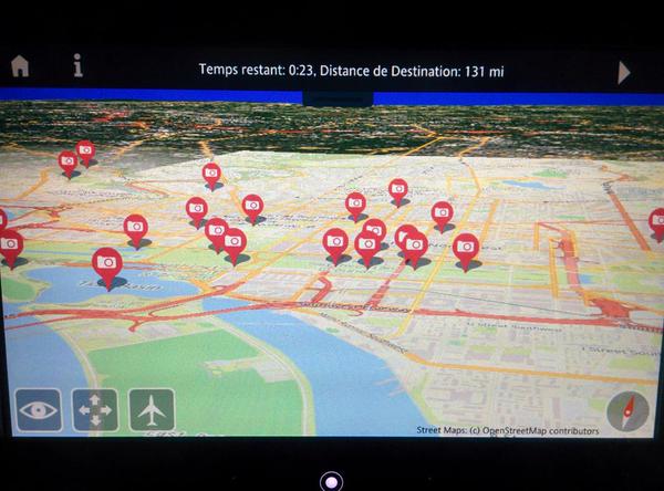
Air France showing OpenStreetMap on a seatback map display.
Photo by Vivien Deparday (posted to twitter)
This is a Featured image, which means that it has been identified as one of the best examples of OpenStreetMap mapping, or that it provides a useful illustration of the OpenStreetMap project. If you know another image of similar quality, you can nominate it on Featured image proposals.
Front-page image for week 32 of 2015 (3–9 Aug.).
- Image descriptions
- asturianu : Les pantalles asitiaes detrás de los asientos de la compañía Air France tienen una vista cartográfica del globu terrestre en 3D qu'utiliza mapes d'OpenStreetMap.
- English : Air France have an interactive 3D globe map view on their seatback displays, with maps from OpenStreetMap!
- français : Les écrans situés à l'arrière des sièges de la compagnie Air France comporte une vue cartographique du globe terrestre en 3D utilisant des cartes d'OpenStreetMap.
- italiano : Air France ha una mappa globale sugli schermi dei sedili: tridimensionale, interattiva e con mappe da OpenStreetMap!
- русский : ОпенСтритМап используют в самолётах компании Эр Франс! Трёхмерная интерактивная карта встроена в дисплеи, расположенные в спинках кресел.
- 中文(简体) : 法国航空在椅背显示器里有3D互动的全球地球,地图资料来自开放街图!
- 中文(繁體) : 法國航空在椅背顯示器裡有3D互動的全球地球,地圖資料來自開放街圖!
Licensing
![]()
![]()
![]()
This work is licensed under the Creative Commons Attribution-ShareAlike 3.0 License.
Attribution not specified as a parameter! THIS LICENSE ALWAYS REQUIRES ATTRIBUTION! Use {{CC-BY-SA-3.0|Attribution, typically name of author}} See Template:CC-BY-SA-3.0 for full description how this template should be used.
Attribution not specified as a parameter! THIS LICENSE ALWAYS REQUIRES ATTRIBUTION! Use {{CC-BY-SA-3.0|Attribution, typically name of author}} See Template:CC-BY-SA-3.0 for full description how this template should be used.
File history
Click on a date/time to view the file as it appeared at that time.
| Date/Time | Thumbnail | Dimensions | User | Comment | |
|---|---|---|---|---|---|
| current | 13:26, 17 July 2015 | | 600 × 444 (48 KB) | Harry Wood (talk | contribs) | Air France showing OpenStreetMap on a seatback map display. Photo by Vivien Deparday ([https://twitter.com/vdeparday/status/621995611605352448 posted to twitter]) |
You cannot overwrite this file.