File:HOT Malawi project 2014 Lilongwe.jpg
Jump to navigation
Jump to search


Size of this preview: 800 × 600 pixels. Other resolutions: 320 × 240 pixels | 640 × 480 pixels | 1,024 × 768 pixels | 1,280 × 960 pixels | 1,600 × 1,200 pixels.
Original file (1,600 × 1,200 pixels, file size: 1.1 MB, MIME type: image/jpeg)
Summary
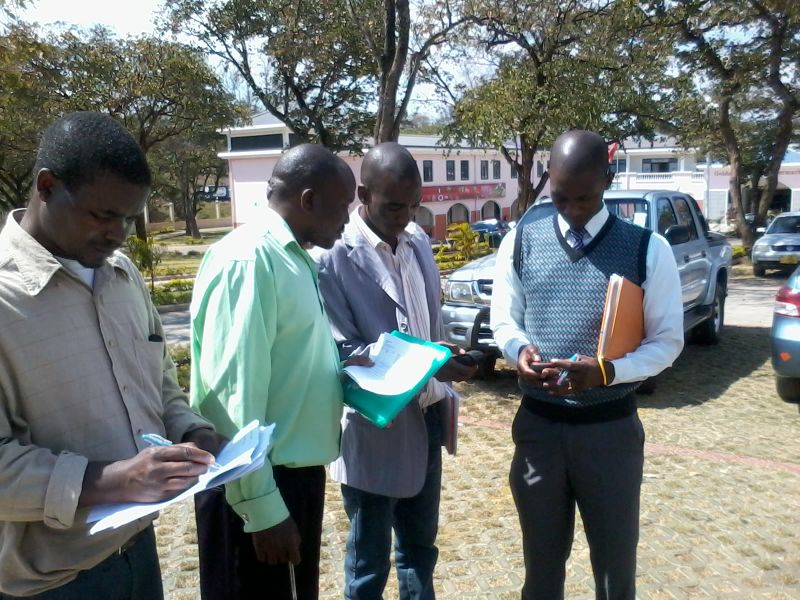
By Maning, from his blog post: http://hot.openstreetmap.org/updates/2014-08-09_osm_workshops_for_project_malawi_week_2
This is a Featured image, which means that it has been identified as one of the best examples of OpenStreetMap mapping, or that it provides a useful illustration of the OpenStreetMap project. If you know another image of similar quality, you can nominate it on Featured image proposals.
Front-page image for week 35 of 2014 (25–31 Aug.).
- Image descriptions
- Deutsch : Die Beamten der Regierung von Malawi erlernen das Erstellen von Karten mit OpenStreetMap. Das Humanitarian OpenStreetMap Team schickte einen Team nach Malawi, um dort Lernkurse zum Thema Kartenerstellen leiten zu können. Außerdem zeigen sie, wie man OSM in ihren offenen GIS-Portal intregieren kann. Mehr dazu im HOT blog
- English : Malawi government officials learning how to create maps with OpenStreetMap. The Humanitarian OpenStreetMap Team have sent a field team to Malawi to run training courses in mapping techniques and also integrating OpenStreetMap into their open GIS data portal. Read more on the HOT blog
- italiano : Funzionari governativi del Malawi imparano a creare mappe con OpenStreetMap. Lo Humanitarian OpenStreetMap Team ha inviato una squadra operativa in Malawi per tenere dei corsi sulle tecniche di mappatura e per integrare OpenStreetMap nel loro portale GIS di open data. Maggiori dettagli nel blog di HOT (in inglese).
- русский : На этой фотографии чиновники Малави изучают процесс картирования. В начале августа несколько членов Гуманитарной команды ОСМ провели курсы по редактированию данных и их интеграции в местный ГИС-портал. Подробности — в блоге.
- 中文(繁體) : 馬拉威政府官員學習如何用開放街圖繪製地圖。人道開放街圖救難小組派遺在地小組到馬拉威,開設關於繪圖技術的訓練課程,以及協助導入開放街圖到馬拉威他們自己的開放GIS資料入口站。到HOT小組部落格瞭解詳情
Licensing
![]()
![]()
![]()
This work is licensed under the Creative Commons Attribution-ShareAlike 2.0 License.
Attribution not specified as a parameter! THIS LICENSE ALWAYS REQUIRES ATTRIBUTION! Use {{CC-BY-SA-2.0|Attribution, typically name of author}} See Template:CC-BY-SA-2.0 for full description how this template should be used.
Note, there is
There is also
Attribution not specified as a parameter! THIS LICENSE ALWAYS REQUIRES ATTRIBUTION! Use {{CC-BY-SA-2.0|Attribution, typically name of author}} See Template:CC-BY-SA-2.0 for full description how this template should be used.
Note, there is
{{CC-BY-SA-2.0 OpenStreetMap}} for files based on old OSM map data, before the license change made on 2012-09-12.There is also
{{OSM Carto screenshot||old_license}} for files based on old OSM map data, before the license change made on 2012-09-12, created using OSM Carto map style.
File history
Click on a date/time to view the file as it appeared at that time.
| Date/Time | Thumbnail | Dimensions | User | Comment | |
|---|---|---|---|---|---|
| current | 13:08, 19 August 2014 | | 1,600 × 1,200 (1.1 MB) | Harry Wood (talk | contribs) | By Maning, from his blog post: http://hot.openstreetmap.org/updates/2014-08-09_osm_workshops_for_project_malawi_week_2 |
You cannot overwrite this file.
File usage
The following 9 pages use this file: