File:Iso3DMap.jpg
Jump to navigation
Jump to search


No higher resolution available.
Iso3DMap.jpg (800 × 414 pixels, file size: 126 KB, MIME type: image/jpeg)
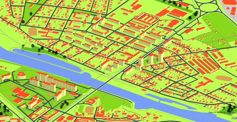
Isometric 3D Map with of Czech Republic - screenshot of Kralupy_nad_Vltavou town [1]
This is a Featured image, which means that it has been identified as one of the best examples of OpenStreetMap mapping, or that it provides a useful illustration of the OpenStreetMap project. If you know another image of similar quality, you can nominate it on Featured image proposals.
Front-page image for week 12 of 2010 (22–28 Mar.).
- Image descriptions
- čeština : Izometrická 3D mapa České republiky – screenshot Kralup nad Vltavou (viz stejné místo generované Mapnikem).
- Deutsch : Eine isometrische 3D Karte von Kralupy nad Vltavou (Kralup an der Moldau, Tschechien). (OSM Carto Version in OSM)
- English : Isometric 3D Map of Czech Republic – screenshot of Kralupy nad Vltavou (see the same place by OSM Carto).
- français : Carte Isométrique 3D de la République Tchèque – image de Kralupy nad Vltavou (voir le même endroit sur OSM Carto).
- italiano : Mappa 3D isometrica con OSM Carto di Kralupy nad Vltavou (Repubblica Ceca) su OSM.
- magyar : Csehország izometrikus 3D térképe – Kralupy nad Vltavou képernyőképe (lásd ugyanezt a helyet Mapnikkal).
- polski : Izomeryczna Mapa 3D Czech, miasta Kralupy nad Wełtawą z wykorzystaniem POV-Raya (a tak wyglada w OSM Carto).
- português : Mapa Isométrico 3D of República Tcheca – screenshot de Kralupy nad Vltavou (veja o mesmo lugar renderizado com OSM Carto).
- русский : Изометрическая 3D-карта Чехии. Изображён город Кралупи-над-Влтавой (это же место на карте Мапник).
File history
Click on a date/time to view the file as it appeared at that time.
| Date/Time | Thumbnail | Dimensions | User | Comment | |
|---|---|---|---|---|---|
| current | 23:28, 14 March 2010 | | 800 × 414 (126 KB) | FrViPofm (talk | contribs) | Isometric 3D Map with mapnik [http://osm.kyblsoft.cz/3dmapa/?zoom=17&lat=75.75078&lon=14.31372&layers=B] |
You cannot overwrite this file.
File usage
The following 6 pages use this file: