File:Juchitan building density map.png
Jump to navigation
Jump to search


Size of this preview: 800 × 456 pixels. Other resolutions: 320 × 182 pixels | 640 × 365 pixels | 1,024 × 583 pixels | 1,499 × 854 pixels.
Original file (1,499 × 854 pixels, file size: 1.19 MB, MIME type: image/png)
Summary
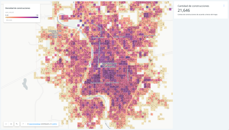
A Carto map ([1]) showing building density after 2017 Mexico Earthquakes mapping efforts in Juchitán, Oaxaca. The HOT Tasking Manager projects were used in the north and in the South
The map was created by @EldesbasteMap
This is a Featured image, which means that it has been identified as one of the best examples of OpenStreetMap mapping, or that it provides a useful illustration of the OpenStreetMap project. If you know another image of similar quality, you can nominate it on Featured image proposals.
Front-page image for week 26 of 2018 (25 Jun. – 1 Jul.).
- Image descriptions
- English : A map (on Carto Builder) showing building density after 2017 Mexico Earthquakes mapping efforts in Juchitán, Oaxaca, created with CARTO.
- français : Une carte (sur Carto Builder) qui montre la densité des bâtiments tracés grâce aux efforts cartographiques suite aux tremblements de terre de 2017 au Mexique à Juchitán (État d’Oaxaca), créée avec CARTO.
- italiano : Una mappa (su Carto Builder) che mostra la densità degli edifici dopo gli sforzi di mappatura dopo i terremoti del 2017 in Messico a Juchitán, Oaxaca, creata con CARTO.
- 中文(简体) : 2017 墨西哥地震画地图行动之后,用CARTO 制作,呈现Oaxaca Juchitán 绘制建筑的密度地图(/590fe30f-6baf-4963-a974-6a5c20d9ed5c/embed 在Carto Builder 上)。
- 中文(繁體) : 2017 墨西哥地震畫地圖行動之後,用 CARTO 製作,呈現 Oaxaca Juchitán 繪製建築的密度地圖 (在 Carto Builder 上)。
Licensing
This image is licensed CC-BY-SA2.0 @EldesbasteMap by permission.
![]()
![]()
![]()
This work is licensed under the Creative Commons Attribution-ShareAlike 2.0 License.
Attribution not specified as a parameter! THIS LICENSE ALWAYS REQUIRES ATTRIBUTION! Use {{CC-BY-SA-2.0|Attribution, typically name of author}} See Template:CC-BY-SA-2.0 for full description how this template should be used.
Note, there is
There is also
Attribution not specified as a parameter! THIS LICENSE ALWAYS REQUIRES ATTRIBUTION! Use {{CC-BY-SA-2.0|Attribution, typically name of author}} See Template:CC-BY-SA-2.0 for full description how this template should be used.
Note, there is
{{CC-BY-SA-2.0 OpenStreetMap}} for files based on old OSM map data, before the license change made on 2012-09-12.There is also
{{OSM Carto screenshot||old_license}} for files based on old OSM map data, before the license change made on 2012-09-12, created using OSM Carto map style.
Note that the image is a screenshot of the Carto website, but mostly showing a custom visualisation created on there by @EldesbasteMap
File history
Click on a date/time to view the file as it appeared at that time.
| Date/Time | Thumbnail | Dimensions | User | Comment | |
|---|---|---|---|---|---|
| current | 22:17, 18 June 2018 | | 1,499 × 854 (1.19 MB) | Harry Wood (talk | contribs) | crop |
| 22:15, 18 June 2018 | 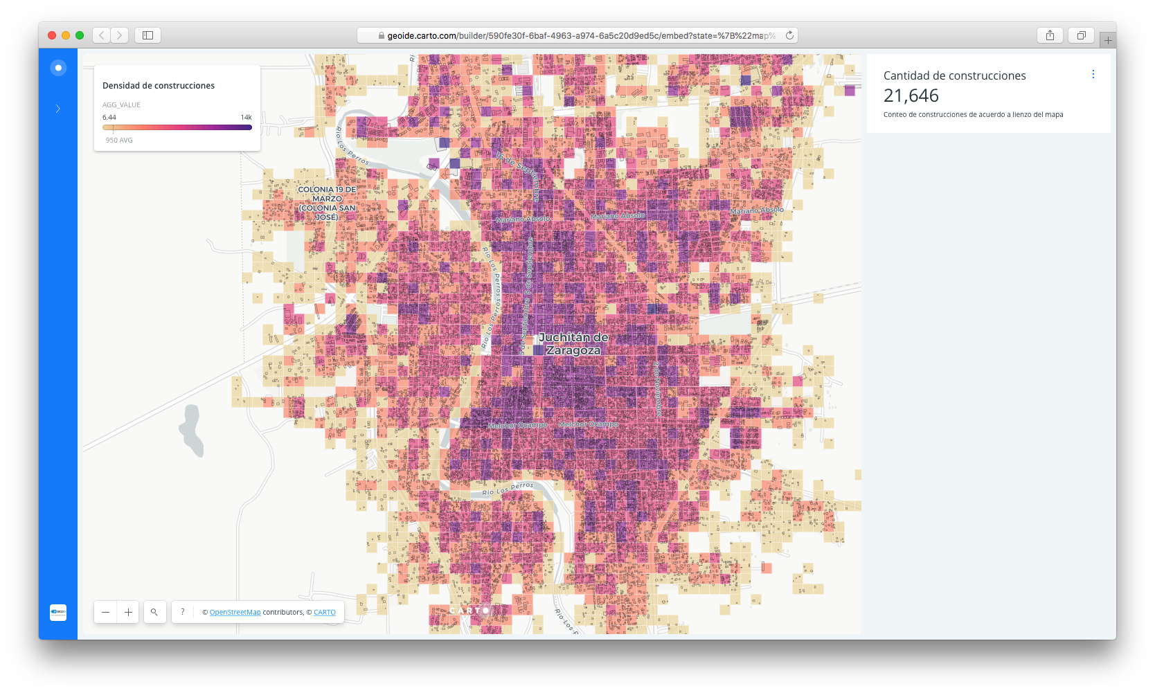 | 1,668 × 1,004 (1.24 MB) | Harry Wood (talk | contribs) | A Carto map ([https://geoide.carto.com/builder/590fe30f-6baf-4963-a974-6a5c20d9ed5c/embed]) showing building density after mapping efforts in Juchitán, Oaxaca, Mexico. The map was created by @EldesbasteMap https://twitter.com/mapanauta/status... |
You cannot overwrite this file.
File usage
The following 10 pages use this file:
- Featured images/Apr-Jun 2018
- Featured images/DE:Apr-Jun 2018
- List of featured images/2018
- Zh-hans:Featured images/Apr-Jun 2018
- Zh-hant:Featured images/Apr-Jun 2018
- Template:Iotw image/2018-26
- DE:Featured images/Apr-Jun 2018
- FR:Featured images/Apr-Jun 2018
- ES:Featured images/Apr-Jun 2018
- IT:Featured images/Apr-Jun 2018