File:Landuse=farmyard and landuse=meadow.jpg
Landuse=farmyard_and_landuse=meadow.jpg (800 × 600 pixels, file size: 106 KB, MIME type: image/jpeg)
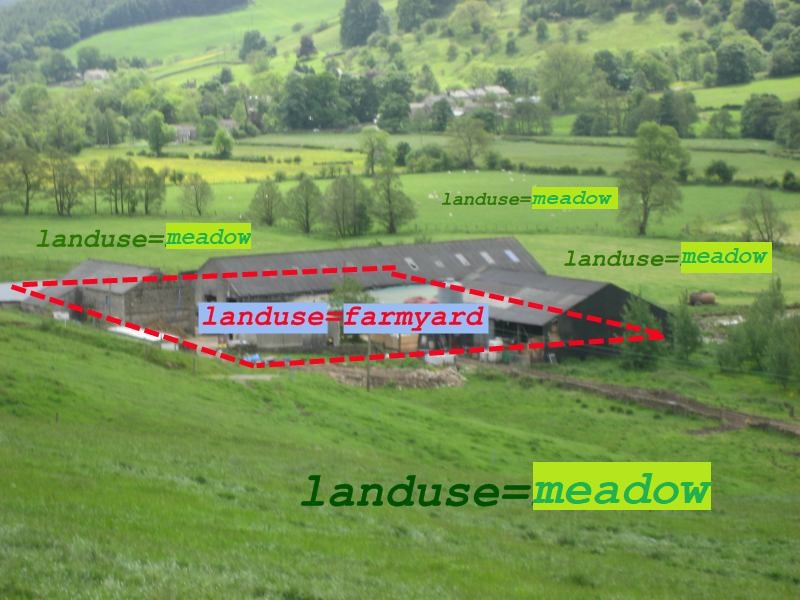
Summary
Illustration of Tag:landuse=farmyard and Tag:landuse=meadow
Modified version showing landuse=meadow created by User:GoodClover on 23:30, 29 June 2021 (originally uploaded as a new version overwriting File:Landuse=farmland.jpg this modified image has been moved here). This is the second modified version (showing a different tag).
The original original by Harry Wood is here: File:Landuse=farmyard and landuse=farm.jpg
The photo was taken by Harry Wood during the Pately Bridge Mapping Party. Beautiful Nidderdale!
Licensing
As with the original by Harry Wood File:Landuse=farmyard.jpg and landuse=farm.jpg this modified version is CC0
![]()
![]()
The person who associated a work with this deed has dedicated the work to the public domain by waiving all of his or her rights to the work worldwide under copyright law, including all related and neighboring rights, to the extent allowed by law. You can copy, modify, distribute and perform the work, even for commercial purposes, all without asking permission.
File history
Click on a date/time to view the file as it appeared at that time.
| Date/Time | Thumbnail | Dimensions | User | Comment | |
|---|---|---|---|---|---|
| current | 18:32, 29 November 2021 | | 800 × 600 (106 KB) | Harry Wood (talk | contribs) | Image created by User:GoodClover on 23:30, 29 June 2021 originally overwriting File:Landuse=farmland.jpg, and as a (2nd) modified version of the original File:Landuse=farmyard.jpg and landuse=farm.jpg |
You cannot overwrite this file.
File usage
The following file is a duplicate of this file (more details):
The following 5 pages use this file: