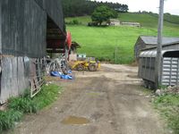
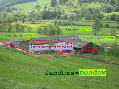
Tag:landuse=farmyard
| Description |
|---|
| Area of land with farm buildings (farmhouse, sheds, stables, barns, etc.) |
| Rendering in OSM Carto |

|
| Group: landuse |
| Used on these elements |
| Useful combination |
| See also |
| Status: approved |
| Tools for this tag |
|
An area of land with farm buildings like farmhouse, dwellings, farmsteads, sheds, stables, barns, equipment sheds, feed bunkers, etc. plus the open space in between them and the shrubbery/trees around them. These areas are often fenced in, and may include fenced livestock feed lots. (American English: barnyard.)
When to use landuse=farmland or landuse=meadow instead
landuse=farmland is used for farm land. The land (fields) around the farm yard. Areas used for tillage and pasture. Wide open space for growing crops or grazing animals. Also see landuse=meadow for pasture used for livestock grazing, and hay meadows. In contast, buildings for keeping animals, or crop supplies would typically be part of a farmyard tagged landuse=farmyard.
How to map
Draw an area around the whole area of the farmyard, and add the tag landuse=farmyard.
Optionally add:
- name=*
- operator=*
- farmyard=* - to specify a particular type of a farmyard, e.g. a feedlot for livestock.
Rendering
Possible tagging mistakes
See also
- landuse=farmland - Area of farmland used mainly for tillage.
- landuse=meadow - An area of meadow or pasture: land primarily vegetated by grass and other non-woody plants, mainly used for hay or grazing.
- shop=farm - A shop at a farm, selling farm produce.
- building=barn - An agricultural building used for storage and as a covered workplace.
- building=slurry_tank - A circular concrete structure holding liquid manure.
- man_made=silo - A storage container for bulk material, often grains such as corn or wheat.
- man_made=storage_tank - A container that holds liquids or compressed gases.
- Approved features/farmyard


