File:OpenRailwayMap Geislinger Steige Hillshades 2016-08-30.jpg
Jump to navigation
Jump to search

No higher resolution available.
OpenRailwayMap_Geislinger_Steige_Hillshades_2016-08-30.jpg (479 × 524 pixels, file size: 189 KB, MIME type: image/jpeg)
Summary
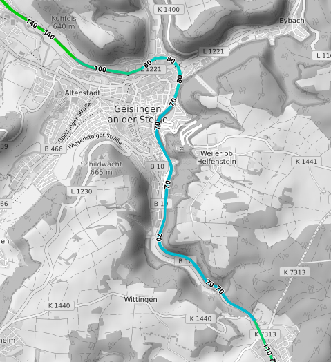
- Deutsch: Zulässige Geschwindigkeiten der Geislinger Steige auf der OpenRailwayMap. Die zusätzlich eingeblendete Schummerung zeigt den Verlauf des Filstals und der umliegenden Gipfel an.
- English: Permissible speeds at the Geislinger Steige, on the railway route between Stuttgart and Munich. Hillshades in the background show the Fils valley and the surrounding summits.
Licensing
| Contains map data © OpenStreetMap contributors, made available under the terms of the Open Database License (ODbL).
The ODbL does not require any particular license for maps produced from ODbL data, produced maps may be subject also to other licences. |
File history
Click on a date/time to view the file as it appeared at that time.
| Date/Time | Thumbnail | Dimensions | User | Comment | |
|---|---|---|---|---|---|
| current | 07:48, 5 September 2016 | | 479 × 524 (189 KB) | Rza31 (talk | contribs) | *Deutsch: Zulässige Geschwindigkeiten der Geislinger Steige auf der OpenRailwayMap. Die zusätzlich eingeblendete Schummerung zeigt den Verlauf des Filstals und der umliegenden Gipfel an. *English: Permissible speeds at the ''Geislinger Steige'', on t... |
You cannot overwrite this file.
File usage
The following 8 pages use this file: