ES:OpenRailwayMap
Si comprendes el artículo original en inglés, por favor, ayuda a completar esta traducción al español. Lee las instrucciones sobre cómo traducir este wiki.
Parece que nadie está trabajando en la traducción en este momento. Anímate y colabora en la tarea de traducción.

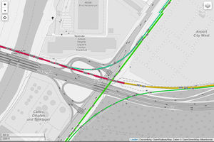
OpenRailwayMap (anteriormente llamado "Bahnkarte") es un mapa en línea detallado del mundo de las infraestructuras ferroviarias, construido sobre OpenStreetMap. Está disponible desde mediados de 2013 en openrailwaymap.org.
Descripción
Este proyecto fue fundado en Diciembre de 2012 con el fin de crear un mapa del mundo detallado, abierto y actualizado de la red de ferrocarriles, basado en OpenStreetMap. El dominio fue registrado el 27 de Abril de 2013 y el sitio web fue lanzado a mediados de 2013. Desde entonces, ha recibido mejoras constantes. En Febrero de 2014, el proyecto fue movido a un nuevo servidor. En Abril de 2014 se lanzó un nuevo mapa dedicado para teléfonos móviles.
OpenRailwayMap incluye todos los vehículos sobre raíles, por ejemplo: ferrocarriles, metros, tranvías, ferrocarriles en miniatura y funiculares. El mapa no incluye monorraíles y maglevs.
El nombre OpenRailwayMap mayoritariamente se refiere al mapa en línea, pero el proyecto también pretende apoyar a la información relacionada con el ferrocarril en OpenStreetMap. Desarrollando un modelo de datos consistente, proveyendo de listados de mail para discusiones, desarrollando plugins de edición, etc. la colección de estos datos es impulsada y la información es útil para otras aplicaciones y desarrolladores.
Motivación
OpenRailwayMap pretende proveer un nuevo mapa de ferrocarriles de calidad y ofrecer los siguientes beneficios:
- Cobertura mundial: Hasta el momento, no había mapas de ferrocarriles que cubran el mundo entero, solo países concretos.
- Código abierto y datos abiertos: Actualmente no hay mapas de redes de ferrocarriles que proporcionen no solo mapas renderizados, sino también los geodatos sin procesar. Todos los mapas actuales no ofrecen esa información mediante licencias gratuitas. Este proyecto está basado en los datos de OpenStreetMap los cuales son publicados mediante la Licencia Abierta de Base de Datos
- Actualizado y detallado: Este mapa pretende beneficiarse del crowdsourcing. Mucha gente de todo el mundo con un buen conocimiento local puede editar este mapa para hacerlo detallado y actualizado.
- OpenStreetMap: Hay muchos mapas basados en OpenStreetMap, por ejemplo, de ciclismo, navegación, transporte público, esquí y mucho más. Sin embargo, no existía un mapa de ferrocarriles.
Casos de uso
There are several good reasons for creating an open, comprehensive railway map of the world. Just some just cases:
- Simulation: Detailed railroad data are an excellent source for simulating trains and signal boxes realisticly.
- Research: Scientists and researchers can use the data to analyse the railroad network, simulate changes and use them for educational purposes.
- Plans for model trains: This detailed railroad data are a good data source for railway enthusiasts, who want to build a railroad line as a model. With these data you do not need to record the railroad tracks anymore.
- Enthusiasts: There are many people interested in railways, e.g. trainspotters. For those people this map provides a detailed information source of the railroad network.
- Basemap for realtime traffic: Other applications can use this map to track the position of trains or to provide a realtime view of the trains' current position. You can also think of applications showing construction sites, detours, blockings and the traffic density.
- Routing: With a detailed mapped railway infrastructure you could develop a routing application.
- Public transport: This map and the data are an important data source for public transport applications like timetables, routing, ... .
Mapeo
For the average mapper mapping the railroad network is a bit more complicated than mapping streets or POIs, but there are some suitable ways of mapping:
- Aerial imagery: Railroad tracks can easily be drawn based on aerial imagery, if high-resolution images are available for your area. With those imagery you can map even great yards simply from home. If you have access to very good high-resolution imagery (e.g. Aerowest), you can also see platforms or even signals.
- In trains: In areas without high-resolution aerial imagery you can track the railroad lines with the GPS while sitting in the train. You should give attention to a sufficient GPS signal in the train to generate exact tracks (see WikiProject_Germany/Railway).
- Along the railroad lines: Especially in rural areas the railroad lines can be accessed easily from ways parallel to the tracks. From there you can map signals or milestones fast, easy and safely. Crossings and bridges are also a good possibility to have a look at a part of the railroad line.
- Stations: In stations you can map a lot of details easy to access and without risk.
- Other sources: Public data, data sources with usage permission, use pictures from trainspotters or videos from the driver's cab after getting their permission,
Note: In all ways of mapping, you have to respect some rules:
- Don't violate general laws: Don't enter railroad areas without permission, don't interrupt the railroad traffic, ... . Use just data you can get from public location (examples are mentioned some lines before)
- Don't put yourself at risk
- Don't use illegal, non-public, confidential or legally doubtful data sources
- Don't violate copyright laws and don't copy from other maps
For newbies: You can donate data, but do not know, how to get into OSM? You have interesting information you can share, but no time to do this yourself? Contact us and send your data with permission so that we might be able do some mapping for you.
Features
- Three overlays based on numerous backgrounds (including hillshades)
- for infrastructure (including milestones, switches, track numbers, signal boxes)
- for signals
- for maximum track speeds
- Numerous search features, stations, milestones and level crossings
- Permalinks
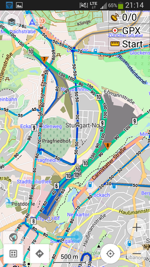
- Dedicated version for mobile phones, open approach for flexible integration in 3rd party applications (such as OsmAnd)
- Daily updates, starting at around 1:00 in the morning (Central European Time), taking about four hours.
- Multiple languages, including: Czech, Danish, Dutch, English, French, German, Greek, N'ko, Polish, Portugese, Russian, Slovenian, Spanish, Swedish, Ukrainian and Vietnamese. As many as 22 translations are available or underway. Translations are coordinated via Transifex.
Algunos ejemplos
There is still a long way to go for both the software and railway data. However, there are already some quite fine examples of OpenRailwayMap's quality:
- Some of the more or less fully railway-mapped areas include the Dresden station area and the Mannheim-Stuttgart high-speed railway line.
- Examples of smaller fully mapped stations include Neuss Hauptbahnhof (a mid-sized railway station in Germany) and Wernigerode, a small station with many signals.
Tagging
For mappers it is recommended to ignore the complex tagging scheme and to use the JOSM presets made for single countries. The presets simplify the complex and general tagging and help make it easier to edit without learning tags.
Country-specific tagging
There are lists of important objects in different countries with examples of how to tag them. Everybody can add a country or add examples to an existing country.
On these pages you can find country-specific information about mapping signals or working rules correctly. There are also some illustrated practical tagging examples. Everybody is invited to add more countries or add some examples for an existing country.
- Australia
- Austria, currently only available in German
- Belgium
- Canada not finished yet
- Czechia (Czech only)
- Finland, currently only available in Finnish
- France
- Germany (ESO, i.e. heavy railways and narrow gauge railways), full version currently only available in German, English translation not finished yet
- Germany (BOStrab, i.e. trams, light rails and subways) (under draft), currently only available in German
- Netherlands
- North America (United States, Canada, and Mexico)
- Poland (not yet finished, see also the earlier German version)
- Russia and post-soviet countries
- Switzerland, currently only available in German
- Sweden
- United Kingdom
- China (currently only available in Chinese)
JOSM presets
For easier mapping you can use the JOSM preset files.
So far, one dedicated JOSM preset has been created. It is aimed at German railway lines and available in the preset directory. There is more information on JOSM tagging presets at the JOSM Tagging presets Wiki page.
Any further presets are very much appreciated. See Contribute.
Software
OpenRailwayMap is Open Source software and is freely available for download under the GPL version 3. It is runs on Linux and services its contents via Apache web server, PHP and Javascript. It is furthermore based on Leaflet, Kothic JS, NodeJS, node-tileserver, osmfilter, osmconvert, osmupdate, osm2pgsql, PostgreSQL and PostGIS. There is also a changelog.
To request certain data, you can use our API. There is also a possibility to include the tiles into other applications. For more information about the terms of use and technical details, please read the API documentation.
Bug reports and suggestions should be reported at the bugtracking system. Users without a Github account can also get in touch with the developers.
Contribuir
Contributors are welcome to help as programmers, translators or designers. Please contact us if you want to contribute.
Mapping: The usability of this map depends on the data. Please use your knowledge to keep the mapped information up-to-date and insert more details!
Programming: You created an interesting new feature or fixed a bug in the existing code? Please send me your code and we will add it.
Translating: OpenRailwayMap wants to be available for many users and in many languages. Please translate the application, the preset files or this wiki page to other languages!
Design: The current design is not very good. Please help to improve it or improve the support in many browsers.
Resources: OpenRailwayMap is currently just a project run in my free time, so needed resources like hardware or domains are limited. You are welcome to support me with these resources!
JOSM-Presets: Create JOSM presets and styles for different countries!
Examples: Add images to the tagging examples or create example pages for new countries!
'Bug reports, browsertests and feature suggestions are desired. Please contact us.
The authors list contains some of the main contributors.
Donaciones
This project is operated by the developers in their spare time and has no commercial goals. By making a donation you can show that you appreciate the voluntary work of the developers and can motivate them to continue the project in the future.
But any donation is not only a form of recognition, but also a financial contribution to the costs that are caused by server, domains, etc.. Only with enough donations the project can be provided without advertising and for free also in the future.
Donations can be made via Paypal and Flattr. On request, donations by bank transfer can be arranged.
Contacto
To contact us, please use one of the following ways:
- Wiki-Message
- OSM-Message
- E-Mail to info@openrailwaymap.org
Mailing list and IRC
- openrailwaymap (en)(de) Mailing list for users and developers of OpenRailwayMap, but also other railway related stuff.
Register - Archive, NNTP gateway via Gmane - #OpenRailwayMap (en)(de) IRC channel for users and developers of OpenRailwayMap, but also other railway related stuff.
irc://irc.oftc.net #OpenRailwayMap or webchat (choose "#openrailwaymap")
Noticias
Eventos
- OpenRailwayMap meetup, 6. June 2014 in Dresden, Germany
- Mapping Weekend 2014, 11.-13. July 2014 in Cologne, Germany
- Project Meeting 2014, 24.-26. October 2014 in Bad Nauheim, Germany
Véase tambien
- OpenRailwayMap Category
- ÖPNV-Karte: A map of lines running on rail and road networks
- OSM Inspector for railways
- ITO Railway Maps
- OSM Tchouchou, trains map, live update in France, Irland, Finland, Denmark
- Train route analysis basado en la información de OSM


